Wreck Wreck

S.S. Annagher

Bangor

Average score: 0

Site name: S.S. Annagher
Location: Descriptive location referring to nearest landfall i.e. town, village, harbour or island
Bangor
Type: Describes whether this dive site can be dived from the shore, from a boat, or both
Shore/Boat
Wreck: Dive sites which include a shipwreck (or part of a shipwreck) are labelled with a ‘Yes’
Yes
Min. dive depth (m): The approximate minimum depth of the dive given in metres
10
Max. dive depth (m): The approximate maximum depth of the dive given in metres
12

Max. seabed depth (m): The maximum depth of the seabed at the site taken from the intersect between the dive site point and the depth contour on an Admiralty Standard Nautical Chart
15

Diving experience (min level): The recommended minimum level of diving experience for a specific site, described as Novice (<50 dives in temperate/cold waters and minimum certification of PADI Open/Advanced Open Water, BSAC Ocean Diver or CMAS 1 star), Intermediate (50-100 dives in temperate/cold waters and minimum certification of PADI Rescue Dive, BSAC Sports Dive or CMAS 2 star) or Advanced (>250 dives in temperate/cold waters and minimum certification of PADI Divemaster, BSAC Dive Leader or CMAS 3 star
Novice

Optimal wind direction: The general wind direction which causes minimal exposure at the site, corresponding to 8 points of the compass: North (N), North East (NE), East (E, South East (SE), South (S), South West (SW), West, North West (NW)
SW

Exposure: The approximate level of exposure to wind and wave action at the site on any given day, described as Sheltered (inshore sites surrounded by a form of shelter on all sides), Moderate (sites which are partially sheltered) or Exposed (sites with little to no shelter)
Exposed

Tidal strength: Anecdotal description of tidal strength at the site
Moderate

Marine Protected Area: A Yes or No highlighting whether or not the site occurs within a Marine Protected Area
No

Visibility: Anecdotal description of the typical underwater visibility at the site
Visibility tends to be poor at this site, ranging from 3-8m
Best time to dive: Anecdotal recommendation for the best time to dive the site for optimal underwater conditions. This typically relates to the stage of the tide
1 hour before HW Belfast
Getting there: Directions for getting to the site

By boat from Bangor or Groomsport. The wreck lies off the northern tip of Ballymaccormick Point.

For a shore dive, follow the footpath leading from The Point in Groomsport towards Ballymacormick Point for approx. 0.5km.

Facilities: Details of nearest facilities to dive site i.e. public car parking and toilets, slipways etc

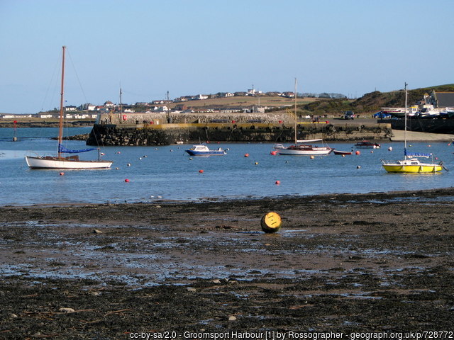
Groomsport has two slipway launching points. There are public toilets on Harbour road. Car parking is available adjacent to the harbour.


Free car parking is available above Bangor Marina and public toilets are available at South Pier. The slipway to the north of the car park is primarily a means of launching Bangor’s Atlantic 85 lifeboat and use is restricted to season ticket holders and Bangor Marina/harbour users. For more information, visit: http://www.quaymarinas.com/cookie-preferences-page/


Nearest tank filling is DV Diving, Mount Stewart, Newtownards.

Hazards: Anecdotal information on possible hazards at the site for divers and snorkellers

  • Lobster pots are set in close proximity to the wreck.
  • Belfast Lough has busy shipping lanes and recreational boating out of Bangor and Groomsport Harbours.
Description: A general description of the physical features of the dive site

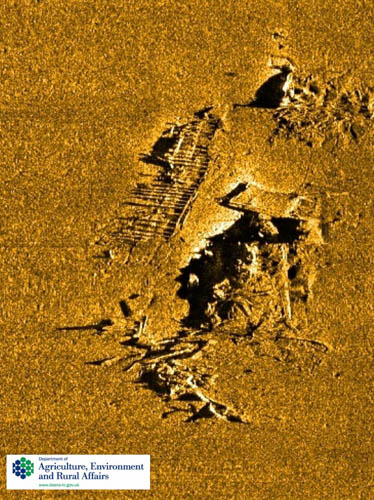
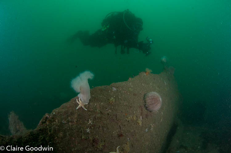
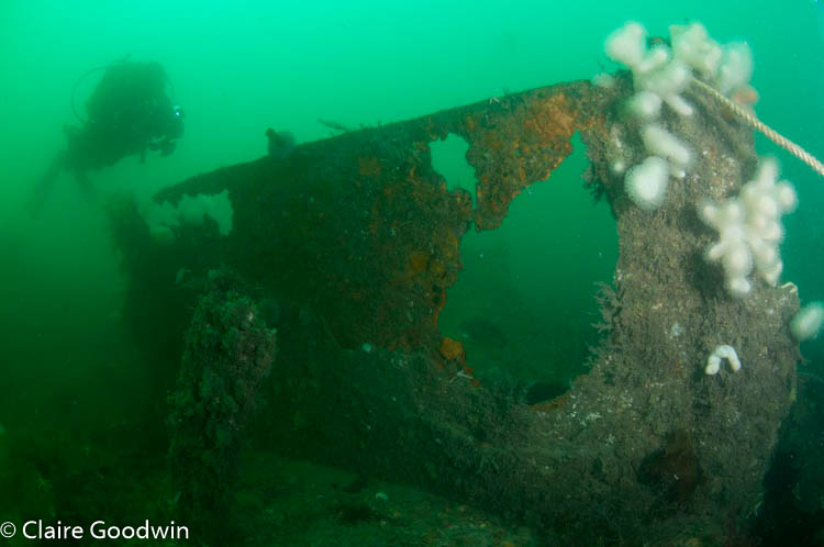
The top of the wreck is at 12 metres, with the base on the seabed at 15 metres. Parts of the wreck are scattered across the surrounding sand and shell seabed, which features many worm burrows and mounds.

History: The history of the wreck provided by the Senior Marine Archaeologist from the Department for Communities Historic Environment Division (only included for wreck sites)

Date of loss 11/12/1937. The Annagher was a British cargo steamship (Steel; LBD: 50.34×8.22×3.4; GT 586). Built in 1923 by J. Lewis & Sons Ltd., Aberdeen. Lost 11 December 1937.Owned by J. Kelly, Ltd., Belfast. Triple-expansion engines, 83HP and capable of 10 knots. En route from Belfast to Llanelly, Wales with a cargo of scrap metal on 11 December 1937. The vessel was carrying a crew of nine under Captain James McCalmont. The vessel developed a list and the crew tried to beach her. This attempt failed and the vessel foundered. 9 lives were lost (other accounts list one survivor, a William Hunter. The wreck was dispersed with explosives. (Sources: AWD; CDSUS 18 Dec. 1937, p.3; CDSUS 8 Jan. 1838, p.7; CDSUS 14 Jan. 1939, p.3; Hocking 1969, p.35; Larn & Larn, 2002).

AWD (Admiralty Wreck Data); CDSUS (Co. Down Spectator and Ulster Standard).

Information derived from Historic Environment Record of Northern Ireland (HERoNI), Department for Communities, Historic Environment Division.

Biodiversity: A description of the species composition at the site. Species of interest are highlighted. Follow the links for more information about the species on the NBN Atlas Northern Ireland website

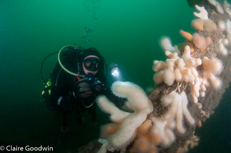
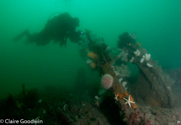
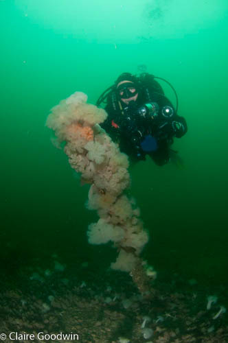
Upper parts of the wreck are covered in dead man’s fingers Alcyonium digitatum and plumose anemones Metridium dianthus. The lower parts have some patches of light-bulb sea squirts Clavelina lepadiformis, but with less life apparent.

View all species records from this site

A link to the dive site location on the NBN Atlas Northern Ireland website, showing all species records from within a 1km boundary of the site centroid. Any new species records from the site submitted to Seasearch, iRecord, CEDaR Online Recording or iNaturalist will appear here
Local charters: A link to the website for the nearest Dive Centre to the site. A map of all dive centres is provided under ‘Go Diving’

D.V. Diving

Environmental and Historical Designations: A list of any environmental or historical designations attributed to the site, or overlapping it. Follow the link for more information

More information: Links to additional information found online for the dive site

Irish Wrecks Online
Wreck Site
Northern Ireland Marine MapViewer

Safety: Safety tips

  • In an emergency call 999 or 112 and ask for the coastguard.
  • Follow VHF radio Channel 16 (156.8 MHz), the international distress frequency. Send a distress alert followed by ‘MAYDAY, MAYDAY, MAYDAY’ and ‘This is [boat name]’.
  • Find nearest defibrillator (AED) here
  • Bangor Harbour Master: 028 9145 3297
  • When navigating within Bangor harbour/marina, use VHF Channel 11
  • Groomsport Harbour Master: 028 9188 2377
Latitude, Longitude: The approximate XY coordinates for the dive site in Decimel Degrees (DD). These can be converted to DMS or DDM by following the link below
54.683417, -5.630483

Watch more videos from SS Annagher

Leave a Comment

Dived here recently? Then let other divers know about this site from your experience!

Leave a Reply

Your email address will not be published. Required fields are marked *

This site uses Akismet to reduce spam. Learn how your comment data is processed.

Join our Mailing List