All Dives Dive

Ardglass Harbour

Ardglass

Average score: 0

Site name: Ardglass Harbour
Location: Descriptive location referring to nearest landfall i.e. town, village, harbour or island
Ardglass
Type: Describes whether this dive site can be dived from the shore, from a boat, or both
Boat
Wreck: Dive sites which include a shipwreck (or part of a shipwreck) are labelled with a ‘Yes’
No
Min. dive depth (m): The approximate minimum depth of the dive given in metres
3
Max. dive depth (m): The approximate maximum depth of the dive given in metres
10

Max. seabed depth (m): The maximum depth of the seabed at the site taken from the intersect between the dive site point and the depth contour on an Admiralty Standard Nautical Chart
10

Diving experience (min level): The recommended minimum level of diving experience for a specific site, described as Novice (<50 dives in temperate/cold waters and minimum certification of PADI Open/Advanced Open Water, BSAC Ocean Diver or CMAS 1 star), Intermediate (50-100 dives in temperate/cold waters and minimum certification of PADI Rescue Dive, BSAC Sports Dive or CMAS 2 star) or Advanced (>250 dives in temperate/cold waters and minimum certification of PADI Divemaster, BSAC Dive Leader or CMAS 3 star
Novice

Optimal wind direction: The general wind direction which causes minimal exposure at the site, corresponding to 8 points of the compass: North (N), North East (NE), East (E, South East (SE), South (S), South West (SW), West, North West (NW)
SW/W/NW/N/NE/E

Exposure: The approximate level of exposure to wind and wave action at the site on any given day, described as Sheltered (inshore sites surrounded by a form of shelter on all sides), Moderate (sites which are partially sheltered) or Exposed (sites with little to no shelter)
Sheltered

Tidal strength: Anecdotal description of tidal strength at the site
Weak

Marine Protected Area: A Yes or No highlighting whether or not the site occurs within a Marine Protected Area
No

Visibility: Anecdotal description of the typical underwater visibility at the site
~4m
Best time to dive: Anecdotal recommendation for the best time to dive the site for optimal underwater conditions. This typically relates to the stage of the tide
HW Slack Ardglass
Getting There: Directions for getting to the site

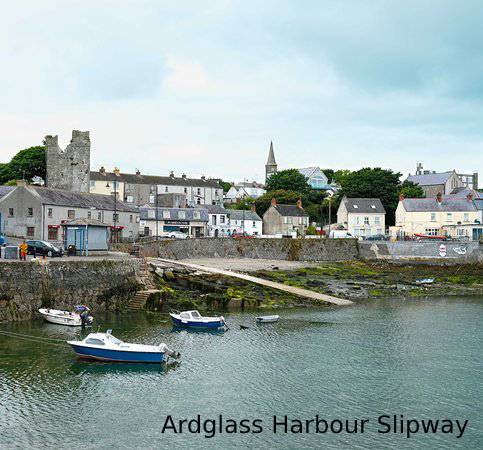
By boat from Ardglass Harbour. The site is beneath the rocky outcrop ~100m NE of the end of the harbour wall.

Facilities: Details of nearest facilities to dive site i.e. public car parking and toilets, slipways etc

Ardglass provides all weather protection for boats and easy offshore access in most weather conditions. The slipway is 20m long and 4m wide. Contact the harbour master in advance (02844841291/07990648274) as this is a busy fishing harbour. Public toilets can be found at 3 Castle cove in the town and there is car parking at the North Pier on Quay street.

Hazards: Anecdotal information on possible hazards at the site for divers and snorkellers

  • Boat traffic.
  • A lot of litter , including golf balls and discarded fishing gloves.
  • Beware of rocky outcrops which are partially hidden at high water (particularly if there is any swell coming into the harbour)
Description: A general description of the physical features of the dive site

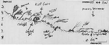
Rocky inlets on the north side of Ardglass Harbour, with a sandy seabed and some boulders. This is a sheltered site and good for training.

Biodiversity: A description of the species composition at the site. Species of interest are highlighted. Follow the links for more information about the species on the NBN Atlas Northern Ireland website

The rocky inlets support dense kelp and a mixed red algae turf and anemones e.g. Dahlia anemone Urticina felina and Snakelocks anemone Anemonia viridis. Look out for the black goby Gobius niger! The sandy seabed is relatively sparse, apart from hydroids (Obelia geniculata in particular) and coralline algae growing on the boulders.

View all species records from this site

A link to the dive site location on the NBN Atlas Northern Ireland website, showing all species records from within a 1km boundary of the site centroid. Any new species records from the site submitted to Seasearch, iRecord, CEDaR Online Recording or iNaturalist will appear here
Local Charters: A link to the website for the nearest Dive Centre to the site. A map of all dive centres is provided under ‘Go Diving’

DV Diving

Environmental and Historical Designations: A list of any environmental or historical designations attributed to the site, or overlapping it. Follow the link for more information

More Information: Links to additional information found online for the dive site

DAERA Marine Map Viewer

Safety: Safety tips

  • In an emergency call 999 or 112 and ask for the coastguard.
  • Follow VHF radio Channel 16 (156.8 MHz), the international distress frequency.
  • Find nearest defibrillator (AED) here
  • Ardglass Harbour Master: 028 44 841291 / 07990648274
  • When navigating within the harbour/marina, use VHF Channel 12
Latitude, Longitude: The approximate XY coordinates for the dive site in Decimel Degrees (DD). These can be converted to DMS or DDM by following the link below
54.261833, -5.601283

Leave a Comment

Dived here recently? Then let other divers know about this site from your experience!

Leave a Reply

Your email address will not be published. Required fields are marked *

This site uses Akismet to reduce spam. Learn how your comment data is processed.

Join our Mailing List