All Dives Dive
Snorkelling Snorkelling

Ballintoy Harbour

Ballintoy

Average score: 0

Site name: Ballintoy Harbour
Location: Descriptive location referring to nearest landfall i.e. town, village, harbour or island
Ballintoy
Type: Describes whether this dive site can be dived from the shore, from a boat, or both
Shore/Boat
Wreck: Dive sites which include a shipwreck (or part of a shipwreck) are labelled with a ‘Yes’
No
Min. dive depth (m): The approximate minimum depth of the dive given in metres
1
Max. dive depth (m): The approximate maximum depth of the dive given in metres
6

Max. seabed depth (m): The maximum depth of the seabed at the site taken from the intersect between the dive site point and the depth contour on an Admiralty Standard Nautical Chart
11

Diving experience (min level): The recommended minimum level of diving experience for a specific site, described as Novice (<50 dives in temperate/cold waters and minimum certification of PADI Open/Advanced Open Water, BSAC Ocean Diver or CMAS 1 star), Intermediate (50-100 dives in temperate/cold waters and minimum certification of PADI Rescue Dive, BSAC Sports Dive or CMAS 2 star) or Advanced (>250 dives in temperate/cold waters and minimum certification of PADI Divemaster, BSAC Dive Leader or CMAS 3 star
Novice

Optimal wind direction: The general wind direction which causes minimal exposure at the site, corresponding to 8 points of the compass: North (N), North East (NE), East (E, South East (SE), South (S), South West (SW), West, North West (NW)
SE/S/SW

Exposure: The approximate level of exposure to wind and wave action at the site on any given day, described as Sheltered (inshore sites surrounded by a form of shelter on all sides), Moderate (sites which are partially sheltered) or Exposed (sites with little to no shelter)
Moderate

Tidal strength: Anecdotal description of tidal strength at the site
Strong

Marine Protected Area: A Yes or No highlighting whether or not the site occurs within a Marine Protected Area
No

Visibility: Anecdotal description of the typical underwater visibility at the site
Visibility is relatively good, ranging from 10-15 metres.
Best time to dive: Anecdotal recommendation for the best time to dive the site for optimal underwater conditions. This typically relates to the stage of the tide
Getting There: Directions for getting to the site

If diving to the west of the harbour wall, around the rocky outcrops, boat cover (from Dunseverick or Ballycastle) is essential. If diving to the east of the harbour, you can access the shore via a pathway which leads down to the ‘secret beach’.

Facilities: Details of nearest facilities to dive site i.e. public car parking and toilets, slipways etc

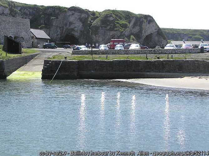
Ballintoy harbour has free car parking, toilets (open 24hours) and a cafe. Arrive early to avoid the Game of Thrones tour buses!

Ballycastle Harbour has a gated slipway (open during office hours) and pontoon berthing (fees apply). For use contact the Ballycastle Harbour Office: 02820768525 / 07803505984. Free car parking is available above the harbour and marina. Free public toilets are available in the visitor information office above the harbour.

Dunseverick has a slipway, small car park and public toilets (open daily from 8am). Be sure not to park on private property!

Nearest tank filling is Aquaholics, Portstewart/ Ballycastle (028 7083 2584)

Hazards: Anecdotal information on possible hazards at the site for divers and snorkellers

  • Strong currents outside the harbour
  • Boat traffic
  • Entanglement in fishing line
Description: A general description of the physical features of the dive site

There are three options for diving or snorkelling at Ballintoy Harbour, either from the beach or rocky outcrops west of the harbour wall or from the secret beach to the east. The rocky outcrops offer many gullies and caverns to explore from all entry points and a blowhole is found off the secret beach to the east.

Biodiversity: A description of the species composition at the site. Species of interest are highlighted. Follow the links for more information about the species on the NBN Atlas Northern Ireland website

The limestone bedrock at this site is covered in dense patches of kelp, a diversity of red algae and invertebrates. On the sandy seabed at the base of the bedrock you may see juvenile flatfish and bobtail squid Sepiola atlantica.

View all species records from this site

A link to the dive site location on the NBN Atlas Northern Ireland website, showing all species records from within a 1km boundary of the site centroid. Any new species records from the site submitted to Seasearch, iRecord, CEDaR Online Recording or iNaturalist will appear here
Local Charters: A link to the website for the nearest Dive Centre to the site. A map of all dive centres is provided under ‘Go Diving’

Aquaholics

Environmental and Historical Designations: A list of any environmental or historical designations attributed to the site, or overlapping it. Follow the link for more information

More Information: Links to additional information found online for the dive site

Aquaholics
Causeway Coast and Glens Heritage Trust Rockpooling, Snorkelling and Diving Guide
Northern Ireland Marine MapViewer

Safety: Safety tips

  • In an emergency call 999 or 112 and ask for the coastguard.
  • Follow VHF radio Channel 16 (156.8 MHz), the international distress frequency.
  • Find nearest defibrillator (AED) here
  • Dunseverick/Ballycastle Harbour Office: 028 207 68525 Mobile Number 07803 505084.
  • When navigating within Dunseverick/Ballycastle Harbour, use VHF Channel 80.
Latitude, Longitude: The approximate XY coordinates for the dive site in Decimel Degrees (DD). These can be converted to DMS or DDM by following the link below
55.244340, -6.369200

Leave a Comment

Dived here recently? Then let other divers know about this site from your experience!

Leave a Reply

Your email address will not be published. Required fields are marked *

This site uses Akismet to reduce spam. Learn how your comment data is processed.

Join our Mailing List