All Dives Dive

Dunluce Reef

Portballintrae

Average score: 0

Site name: Dunluce Reef
Location: Descriptive location referring to nearest landfall i.e. town, village, harbour or island
Portballintrae
Type: Describes whether this dive site can be dived from the shore, from a boat, or both
Boat
Wreck: Dive sites which include a shipwreck (or part of a shipwreck) are labelled with a ‘Yes’
No
Min. dive depth (m): The approximate minimum depth of the dive given in metres
2
Max. dive depth (m): The approximate maximum depth of the dive given in metres
13

Max. seabed depth (m): The maximum depth of the seabed at the site taken from the intersect between the dive site point and the depth contour on an Admiralty Standard Nautical Chart
23.5

Diving experience (min level): The recommended minimum level of diving experience for a specific site, described as Novice (<50 dives in temperate/cold waters and minimum certification of PADI Open/Advanced Open Water, BSAC Ocean Diver or CMAS 1 star), Intermediate (50-100 dives in temperate/cold waters and minimum certification of PADI Rescue Dive, BSAC Sports Dive or CMAS 2 star) or Advanced (>250 dives in temperate/cold waters and minimum certification of PADI Divemaster, BSAC Dive Leader or CMAS 3 star
Intermediate

Optimal wind direction: The general wind direction which causes minimal exposure at the site, corresponding to 8 points of the compass: North (N), North East (NE), East (E, South East (SE), South (S), South West (SW), West, North West (NW)
E/SE/S/SW

Exposure: The approximate level of exposure to wind and wave action at the site on any given day, described as Sheltered (inshore sites surrounded by a form of shelter on all sides), Moderate (sites which are partially sheltered) or Exposed (sites with little to no shelter)
Sheltered

Tidal strength: Anecdotal description of tidal strength at the site
Moderate

Marine Protected Area: A Yes or No highlighting whether or not the site occurs within a Marine Protected Area
Yes

Visibility: Anecdotal description of the typical underwater visibility at the site
~7-10 metres
Best time to dive: Anecdotal recommendation for the best time to dive the site for optimal underwater conditions. This typically relates to the stage of the tide
Getting There: Directions for getting to the site

By boat from Portballintrae or Portrush, the site lies ~500m NE off Dunluce Castle.

Facilities: Details of nearest facilities to dive site i.e. public car parking and toilets, slipways etc

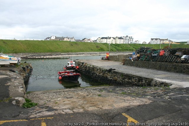
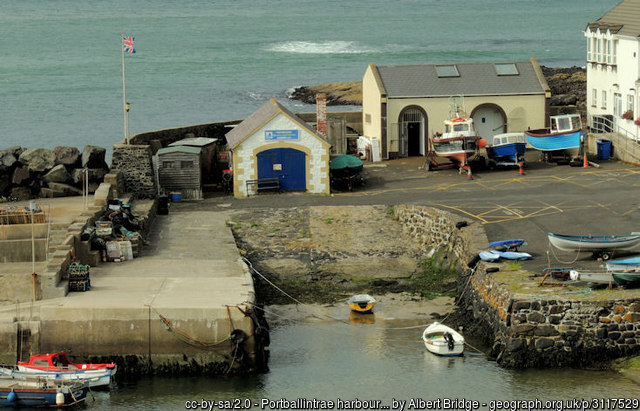
Portballintrae Harbour has a slipway (although access is tight and the harbour can be busy during peak holiday times), free car parking on Beach Road, above the Harbour, and public toilets above the harbour wall.

Portrush Harbour offers free car parking above the harbour, public toilets in the harbour office and a slipway on the North Pier. There is a barrier to the harbour which is staffed during office hours, 7 days a week from April – September.

Fees apply for berthing at both Portballintrae and Portrush; for use contact Portrush Harbour Office: 02870822307 / 0788981860.

Nearest tank filling is Aquaholics in Ballycastle or Portstewart (ring ahead: 028 7083 2584)

Hazards: Anecdotal information on possible hazards at the site for divers and snorkellers

  • Currents can be strong here, depending on stage of the tide.
Description: A general description of the physical features of the dive site

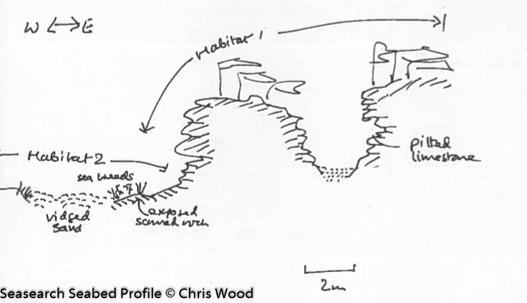
A limestone reef, with many crevices, a narrow 2 metre gully, and several overhangs. The seabed at the base of the slope is made up of cobbles and pebbles.

Biodiversity: A description of the species composition at the site. Species of interest are highlighted. Follow the links for more information about the species on the NBN Atlas Northern Ireland website

The top of the limestone reef is covered in kelp and mixed red algae, while the verticle walls are colonised by sea squirts. Common sea urchins Echinus esculentus and common starfish Asterias rubens are often abundant at the site. The rare sponge species Haliclona simulans has been recorded here. This is the only record of this species from the North Coast, but this may be due to its polymorphic nature, growing as a branching erect colony or thin sheet, making identification difficult.

View all species records from this site

A link to the dive site location on the NBN Atlas Northern Ireland website, showing all species records from within a 1km boundary of the site centroid. Any new species records from the site submitted to Seasearch, iRecord, CEDaR Online Recording or iNaturalist will appear here
Local Charters: A link to the website for the nearest Dive Centre to the site. A map of all dive centres is provided under ‘Go Diving’

Aquaholics

Environmental and Historical Designations: A list of any environmental or historical designations attributed to the site, or overlapping it. Follow the link for more information

Skerries and Causeway SAC

More Information: Links to additional information found online for the dive site

Northern Ireland Marine MapViewer

Safety: Safety tips

  • In an emergency call 999 or 112 and ask for the coastguard.
  • Follow VHF radio Channel 16 (156.8 MHz), the international distress frequency. Send a distress alert followed by ‘MAYDAY, MAYDAY, MAYDAY’ and ‘This is [boat name]’.
  • Find nearest defibrillator (AED) here.
  • Portrush/Portballintrae Harbour Office: 02870822307 / 0788981860
  • When navigating within the harbour, use VHF Channel 12.
Latitude, Longitude: The approximate XY coordinates for the dive site in Decimel Degrees (DD). These can be converted to DMS or DDM by following the link below
55.215306, -6.577583

Leave a Comment

Dived here recently? Then let other divers know about this site from your experience!

Leave a Reply

Your email address will not be published. Required fields are marked *

This site uses Akismet to reduce spam. Learn how your comment data is processed.

Join our Mailing List