
Site name: Greenore Shore
Location: Descriptive location referring to nearest landfall i.e. town, village, harbour or island
Carlingford LoughType: Describes whether this dive site can be dived from the shore, from a boat, or both
ShoreWreck: Dive sites which include a shipwreck (or part of a shipwreck) are labelled with a ‘Yes’
NoMin. dive depth (m): The approximate minimum depth of the dive given in metres
2Max. dive depth (m): The approximate maximum depth of the dive given in metres
17Max. seabed depth (m): The maximum depth of the seabed at the site taken from the intersect between the dive site point and the depth contour on an Admiralty Standard Nautical Chart
17Diving experience (min level): The recommended minimum level of diving experience for a specific site, described as Novice (<50 dives in temperate/cold waters and minimum certification of PADI Open/Advanced Open Water, BSAC Ocean Diver or CMAS 1 star), Intermediate (50-100 dives in temperate/cold waters and minimum certification of PADI Rescue Dive, BSAC Sports Dive or CMAS 2 star) or Advanced (>250 dives in temperate/cold waters and minimum certification of PADI Divemaster, BSAC Dive Leader or CMAS 3 star
NoviceOptimal wind direction: The general wind direction which causes minimal exposure at the site, corresponding to 8 points of the compass: North (N), North East (NE), East (E, South East (SE), South (S), South West (SW), West, North West (NW)
S/SE/WExposure: The approximate level of exposure to wind and wave action at the site on any given day, described as Sheltered (inshore sites surrounded by a form of shelter on all sides), Moderate (sites which are partially sheltered) or Exposed (sites with little to no shelter)
ModerateTidal strength: Anecdotal description of tidal strength at the site
ModerateMarine Protected Area: A Yes or No highlighting whether or not the site occurs within a Marine Protected Area
NoVisibility: Anecdotal description of the typical underwater visibility at the site
Best time to dive: Anecdotal recommendation for the best time to dive the site for optimal underwater conditions. This typically relates to the stage of the tide
Slack water GreenoreGetting There: Directions for getting to the site
Follow Shore Road into Greenore and turn right at the T junction to park in the lay-by above the beach. Access the shore from here on foot.
Facilities: Details of nearest facilities to dive site i.e. public car parking and toilets, slipways etc
The nearest public toilets are in Carlingford village. Free car parking is available above the site: https://goo.gl/maps/Xv6PPocjis3ftBMP9
Hazards: Anecdotal information on possible hazards at the site for divers and snorkellers
- The site is very close to the Greenore – Greencastle ferry lane (surface marker buoy and vigilant surface cover vital)
Description: A general description of the physical features of the dive site
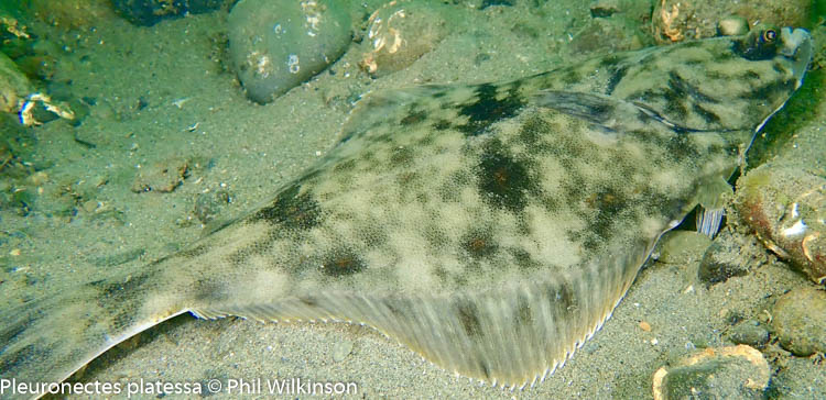
A silty, cobbled slope.
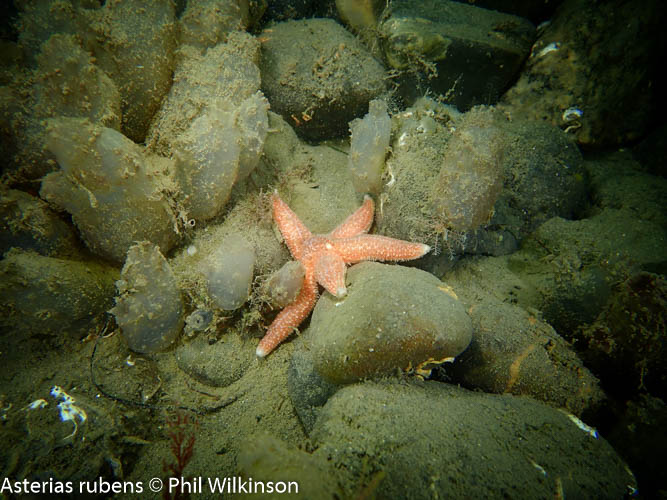
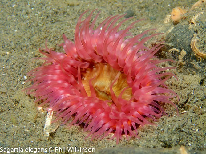
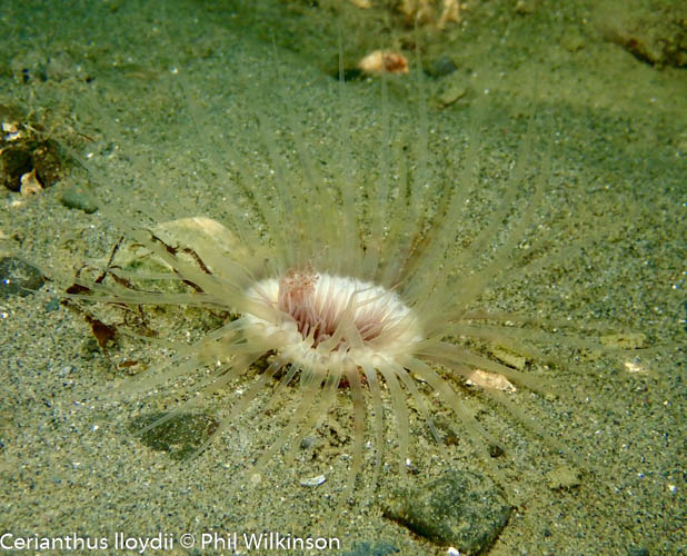
Biodiversity: A description of the species composition at the site. Species of interest are highlighted. Follow the links for more information about the species on the NBN Atlas Northern Ireland website
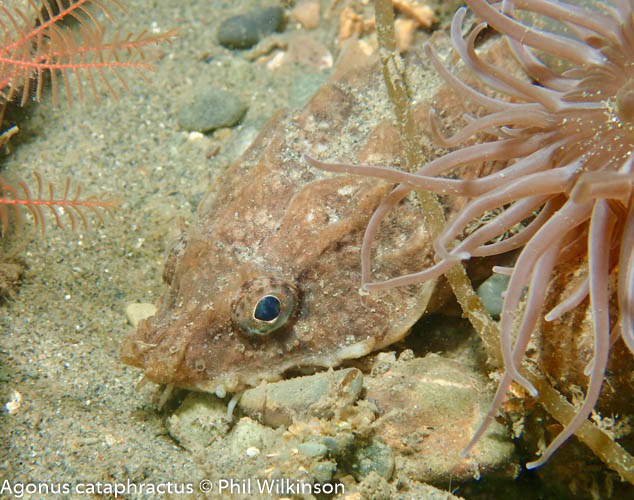
The site supports a diversity of crustaceans and fish species, including shanny, gobies and butterfish. Pairs of butterfish were filmed displaying mating behaviour at the site in October 2018 by Seasearch divers. The invasive leathery sea squirt Styela clava has been recorded here recently.
View all species records from this site
A link to the dive site location on the NBN Atlas Northern Ireland website, showing all species records from within a 1km boundary of the site centroid. Any new species records from the site submitted to Seasearch, iRecord, CEDaR Online Recording or iNaturalist will appear hereLocal Charters: A link to the website for the nearest Dive Centre to the site. A map of all dive centres is provided under ‘Go Diving’
Environmental and Historical Designations: A list of any environmental or historical designations attributed to the site, or overlapping it. Follow the link for more information
More Information: Links to additional information found online for the dive site
Safety: Safety tips
- In an emergency call 999 or 112 and ask for the coastguard.
- Follow VHF radio Channel 16 (156.8 MHz), the international distress frequency. Send a distress alert followed by ‘MAYDAY, MAYDAY, MAYDAY’ and ‘This is [boat name]’.
- Find nearest defibrillator (AED) here.
- Carlingford Marina Office: +353 42 937 3072
- When navigating within the harbour/marina, use VHF Channel 12/16.
Latitude, Longitude: The approximate XY coordinates for the dive site in Decimel Degrees (DD). These can be converted to DMS or DDM by following the link below
54.032479, -6.130369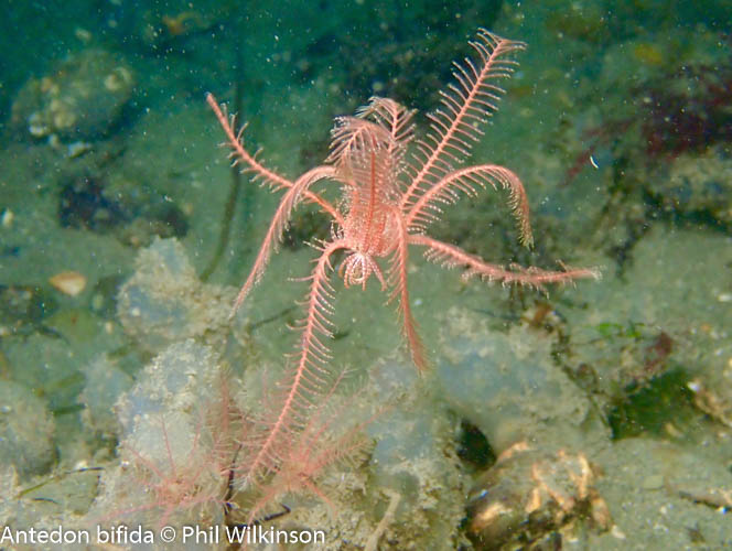


Hello folks,
I’m looking into charting a boat in order to scatter my father’s ashes in the Irish sea (he was a merchant seaman).
Is this something you’re able to offer or know someone who can?
Thank you,
Caoimhin
07596 500865