Location:Descriptive location referring to nearest landfall i.e. town, village, harbour or island
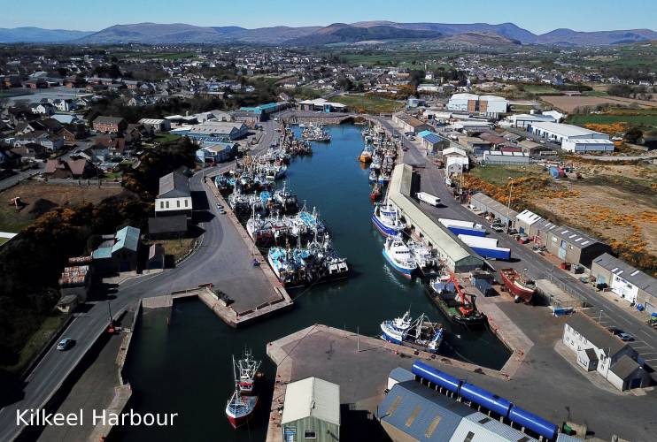
Kilkeel
Type:Describes whether this dive site can be dived from the shore, from a boat, or both
Boat
Wreck:Dive sites which include a shipwreck (or part of a shipwreck) are labelled with a ‘Yes’
Yes
Min. dive depth (m):The approximate minimum depth of the dive given in metres
23
Max. dive depth (m):The approximate maximum depth of the dive given in metres
28
Max. seabed depth (m):The maximum depth of the seabed at the site taken from the intersect between the dive site point and the depth contour on an Admiralty Standard Nautical Chart
28
Diving experience (min level):The recommended minimum level of diving experience for a specific site, described as Novice (<50 dives in temperate/cold waters and minimum certification of PADI Open/Advanced Open Water, BSAC Ocean Diver or CMAS 1 star), Intermediate (50-100 dives in temperate/cold waters and minimum certification of PADI Rescue Dive, BSAC Sports Dive or CMAS 2 star) or Advanced (>250 dives in temperate/cold waters and minimum certification of PADI Divemaster, BSAC Dive Leader or CMAS 3 star
Advanced
Optimal wind direction:The general wind direction which causes minimal exposure at the site, corresponding to 8 points of the compass: North (N), North East (NE), East (E, South East (SE), South (S), South West (SW), West, North West (NW)
W/NW/N
Exposure:The approximate level of exposure to wind and wave action at the site on any given day, described as Sheltered (inshore sites surrounded by a form of shelter on all sides), Moderate (sites which are partially sheltered) or Exposed (sites with little to no shelter)
Exposed
Tidal strength:Anecdotal description of tidal strength at the site
Marine Protected Area:A Yes or No highlighting whether or not the site occurs within a Marine Protected Area
Yes
Visibility:Anecdotal description of the typical underwater visibility at the site
~5m
Best time to dive:Anecdotal recommendation for the best time to dive the site for optimal underwater conditions. This typically relates to the stage of the tide
Getting there:Directions for getting to the site
By boat from Kilkeel or Annalong. The site is ~4km SE of Kilkeel.
Facilities:Details of nearest facilities to dive site i.e. public car parking and toilets, slipways etc
The harbour at Kilkeel is a busy fishing port. A small slipway and pontoon berths are available but there is a charge. For details visit www.nifha.co.uk/pages/kilkeel-harbour/. Entrance to the harbour can be restricted by fishing activity and so dive boats are advised to use Annalong.
Annalong harbour has a small slipway on the north side of the entrance to Annalong, while pontoons are available inside the harbour. Car parking is available on Glassdrumman road (if using the slipway) and public toilets are available beside Annalong Cornmill.
Hazards:Anecdotal information on possible hazards at the site for divers and snorkellers
Commercial and recreational boats in the area.
There are ropes and fishing nets attached to the wreck (entanglement hazard)
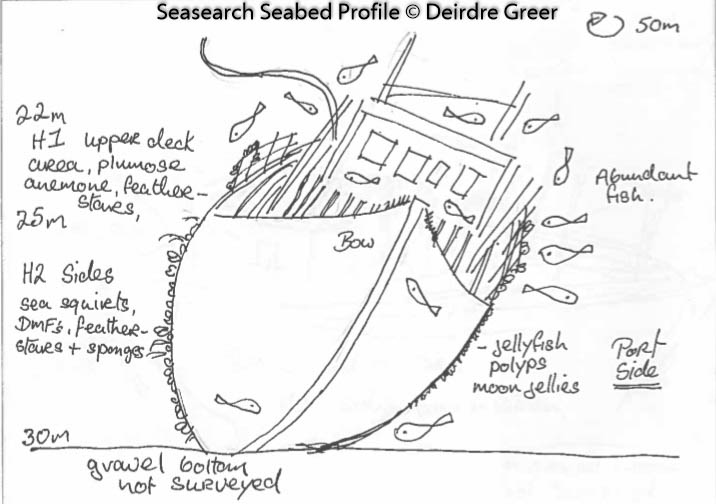
Description:A general description of the physical features of the dive site
The wreck lies largely intact, tilted on a sand bank with just the wheel house missing. The seabed surrounding the vessel consists of sandy sediment and patches of gravel.
History:The history of the wreck provided by the Senior Marine Archaeologist from the Department for Communities Historic Environment Division (only included for wreck sites)
Biodiversity:A description of the species composition at the site. Species of interest are highlighted. Follow the links for more information about the species on the NBN Atlas Northern Ireland website
A link to the dive site location on the NBN Atlas Northern Ireland website, showing all species records from within a 1km boundary of the site centroid. Any new species records from the site submitted to Seasearch, iRecord, CEDaR Online Recording or iNaturalist will appear here
Local charters:A link to the website for the nearest Dive Centre to the site. A map of all dive centres is provided under ‘Go Diving’
Environmental and Historical Designations:A list of any environmental or historical designations attributed to the site, or overlapping it. Follow the link for more information
In an emergency call 999 or 112 and ask for the coastguard.
Follow VHF radio Channel 16 (156.8 MHz), the international distress frequency. Send a distress alert followed by ‘MAYDAY, MAYDAY, MAYDAY’ and ‘This is [boat name]’.
Latitude, Longitude:The approximate XY coordinates for the dive site in Decimel Degrees (DD). These can be converted to DMS or DDM by following the link below


Leave a Comment
Dived here recently? Then let other divers know about this site from your experience!