Location:Descriptive location referring to nearest landfall i.e. town, village, harbour or island
Ballyquintin Point
Type:Describes whether this dive site can be dived from the shore, from a boat, or both
Boat
Wreck:Dive sites which include a shipwreck (or part of a shipwreck) are labelled with a ‘Yes’
Yes
Min. dive depth (m):The approximate minimum depth of the dive given in metres
Max. dive depth (m):The approximate maximum depth of the dive given in metres
34
Max. seabed depth (m):The maximum depth of the seabed at the site taken from the intersect between the dive site point and the depth contour on an Admiralty Standard Nautical Chart
34
Diving experience (min level):The recommended minimum level of diving experience for a specific site, described as Novice (<50 dives in temperate/cold waters and minimum certification of PADI Open/Advanced Open Water, BSAC Ocean Diver or CMAS 1 star), Intermediate (50-100 dives in temperate/cold waters and minimum certification of PADI Rescue Dive, BSAC Sports Dive or CMAS 2 star) or Advanced (>250 dives in temperate/cold waters and minimum certification of PADI Divemaster, BSAC Dive Leader or CMAS 3 star
Advanced
Optimal wind direction:The general wind direction which causes minimal exposure at the site, corresponding to 8 points of the compass: North (N), North East (NE), East (E, South East (SE), South (S), South West (SW), West, North West (NW)
W/SW
Exposure:The approximate level of exposure to wind and wave action at the site on any given day, described as Sheltered (inshore sites surrounded by a form of shelter on all sides), Moderate (sites which are partially sheltered) or Exposed (sites with little to no shelter)
Exposed
Tidal strength:Anecdotal description of tidal strength at the site
Marine Protected Area:A Yes or No highlighting whether or not the site occurs within a Marine Protected Area
Yes
Visibility:Anecdotal description of the typical underwater visibility at the site
Best time to dive:Anecdotal recommendation for the best time to dive the site for optimal underwater conditions. This typically relates to the stage of the tide
Getting there:Directions for getting to the site
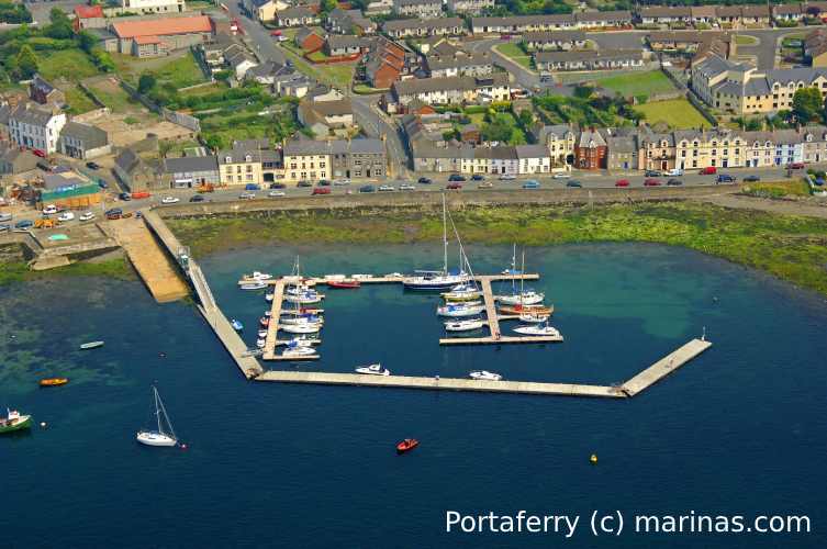
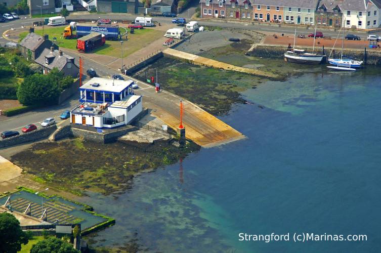
By boat from Strangford or Portaferry. The site is approximately 2km SE of Ballyquintin Point.
Facilities:Details of nearest facilities to dive site i.e. public car parking and toilets, slipways etc
In Strangford, free parking is available above the marina and a slipway is available at the quays. Public toilets are available at the ferry terminal.
In Portaferry free car parking is available on Meeting House Street beside the arts centre, 300 metres from the harbour slipway. Public toilets are available in the town, close to Castle Park.
Nearest tank filling is DV Diving, Mount Stewart, Newtownards.
Hazards:Anecdotal information on possible hazards at the site for divers and snorkellers
Description:A general description of the physical features of the dive site
Large, fairly broken up, wreck lying on level seabed at 32 metres.
History:The history of the wreck provided by the Senior Marine Archaeologist from the Department for Communities Historic Environment Division (only included for wreck sites)
Date of loss 18/10/1918. A British merchant vessel, in ballast, sunk without warning by a submarine torpedo, from UB 92. 1 life was lost. The Hunsdon was armed for defensive purposes. 2899 gross tonnage. Its voyage was from Le Havre to Belfast. It was sunk c. 75m SE of Strangford light buoy. The Hunsdon was a German prize, built of steel by the Weserr Company at Bremen for the Hamburg-Afrika Line and was launched in April 1911 under the name Arnfried. Her dimensions were – length 335.3 ft., breadth 48.1 ft., depth 21.1.’ (JUAHS 1979 p.10). In 1914 the vessel was captured off Africa and was renamed the Hunsdon and managed by Elder Dempster and Co. Ltd until 1917. (A detailed account of the career and loss of the Hunsdon is contained in JUAHS.) The wreck lies in a general depth of 36m. (Sources: AWD; CSP 1919 Vol. 42 p.72; JUAHS 1979 p.10).
AWD (Admiralty Wreck Data); CSP (Commons Sessional Papers); JUAHS (Journal of the Upper Ards Historical Society).
Information derived from Historic Environment Record of Northern Ireland (HERoNI), Department for Communities, Historic Environment Division.
Biodiversity:A description of the species composition at the site. Species of interest are highlighted. Follow the links for more information about the species on the NBN Atlas Northern Ireland website
A link to the dive site location on the NBN Atlas Northern Ireland website, showing all species records from within a 1km boundary of the site centroid. Any new species records from the site submitted to Seasearch, iRecord, CEDaR Online Recording or iNaturalist will appear here
Local charters:A link to the website for the nearest Dive Centre to the site. A map of all dive centres is provided under ‘Go Diving’
Environmental and Historical Designations:A list of any environmental or historical designations attributed to the site, or overlapping it. Follow the link for more information
In an emergency call 999 or 112 and ask for the coastguard.
Follow VHF radio Channel 16 (156.8 MHz), the international distress frequency. Send a distress alert followed by ‘MAYDAY, MAYDAY, MAYDAY’ and ‘This is [boat name]’.
When navigating within the harbour/marina, use VHF Channel 80
Latitude, Longitude:The approximate XY coordinates for the dive site in Decimel Degrees (DD). These can be converted to DMS or DDM by following the link below


Leave a Comment
Dived here recently? Then let other divers know about this site from your experience!