All Dives Dive

Isle of Muck North

Islandmagee

Average score: 0

Site name: Isle of Muck North
Location: Descriptive location referring to nearest landfall i.e. town, village, harbour or island
Islandmagee
Type: Describes whether this dive site can be dived from the shore, from a boat, or both
Boat
Wreck: Dive sites which include a shipwreck (or part of a shipwreck) are labelled with a ‘Yes’
No
Min. dive depth (m): The approximate minimum depth of the dive given in metres
11
Max. dive depth (m): The approximate maximum depth of the dive given in metres
22

Max. seabed depth (m): The maximum depth of the seabed at the site taken from the intersect between the dive site point and the depth contour on an Admiralty Standard Nautical Chart
27

Diving experience (min level): The recommended minimum level of diving experience for a specific site, described as Novice (<50 dives in temperate/cold waters and minimum certification of PADI Open/Advanced Open Water, BSAC Ocean Diver or CMAS 1 star), Intermediate (50-100 dives in temperate/cold waters and minimum certification of PADI Rescue Dive, BSAC Sports Dive or CMAS 2 star) or Advanced (>250 dives in temperate/cold waters and minimum certification of PADI Divemaster, BSAC Dive Leader or CMAS 3 star
Intermediate

Optimal wind direction: The general wind direction which causes minimal exposure at the site, corresponding to 8 points of the compass: North (N), North East (NE), East (E, South East (SE), South (S), South West (SW), West, North West (NW)
SW/W

Exposure: The approximate level of exposure to wind and wave action at the site on any given day, described as Sheltered (inshore sites surrounded by a form of shelter on all sides), Moderate (sites which are partially sheltered) or Exposed (sites with little to no shelter)
Exposed

Tidal strength: Anecdotal description of tidal strength at the site
Moderate

Marine Protected Area: A Yes or No highlighting whether or not the site occurs within a Marine Protected Area
Yes

Visibility: Anecdotal description of the typical underwater visibility at the site
~5m
Best time to dive: Anecdotal recommendation for the best time to dive the site for optimal underwater conditions. This typically relates to the stage of the tide
Getting There: Directions for getting to the site

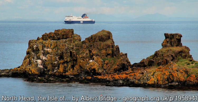
By boat from Portmuck or Ballylumford. The site is ~50m off the north point of Portmuck Island.

Facilities: Details of nearest facilities to dive site i.e. public car parking and toilets, slipways etc

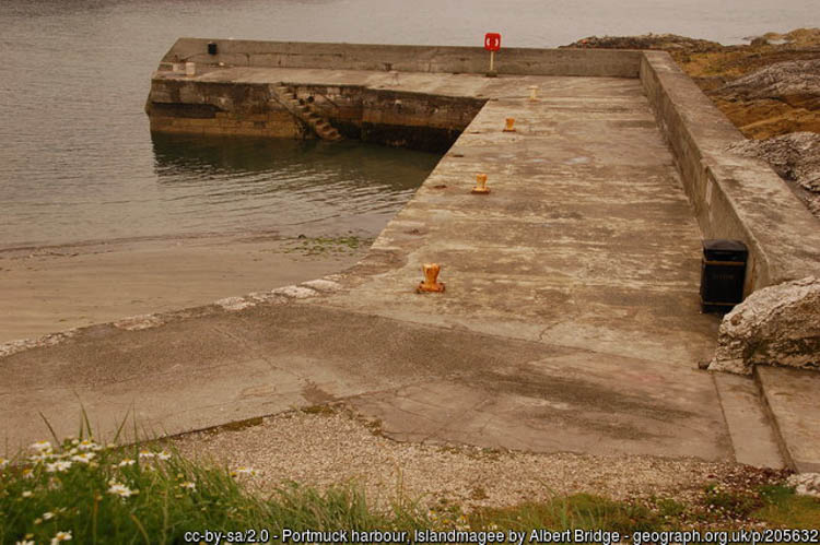
Portmuck Harbour provides free car parking, a slipway and public toilets. The pier is 25 metres long, 6.5 metres wide and in good condition.

Free parking, a slipway, public toilets and outdoor changing facilities are available at Ballylumford Harbour as well (access to slipway restricted to Islandmagee Boat Club members; email: info@islandmageeboatclub.co.uk).

Nearest tank filling is DV Diving, Mount Stewart, Newtownards.

Hazards: Anecdotal information on possible hazards at the site for divers and snorkellers

  • The site is moderately exposed, particularly to the eastern side of the island, and caution is required
Description: A general description of the physical features of the dive site

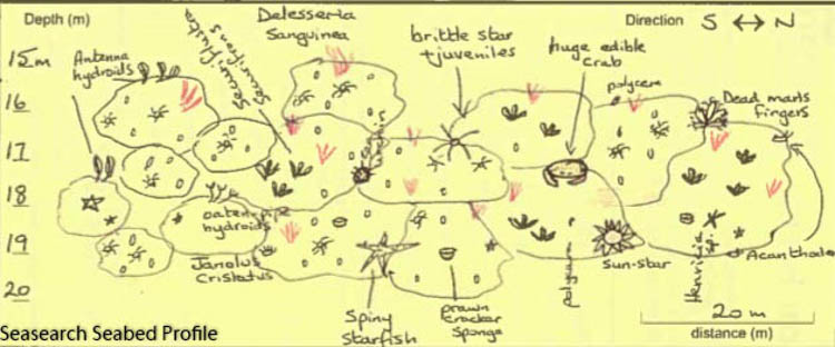
A vertical bedrock wall, 2-3m high with crevices and often heavillly silted. The seabed at the base of the wall is characterised by small boulders on fragmented shell, which slopes downwards into pebbles and cobbles.The seabed flattens out at approx. 19m where it is made up of sand and gravel.

Biodiversity: A description of the species composition at the site. Species of interest are highlighted. Follow the links for more information about the species on the NBN Atlas Northern Ireland website

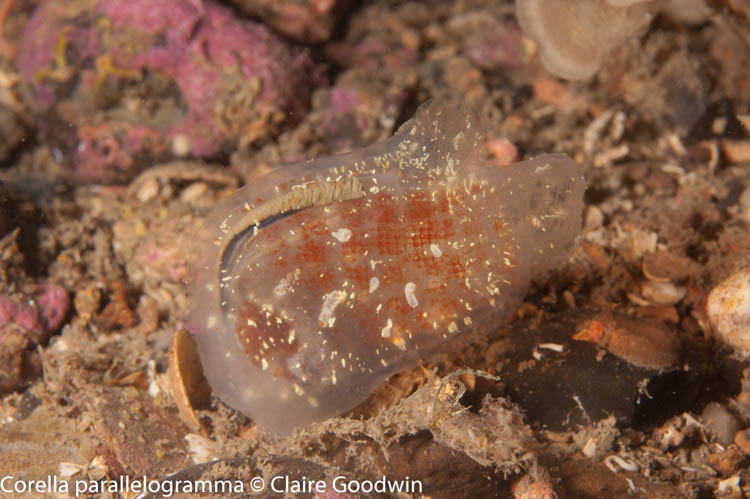
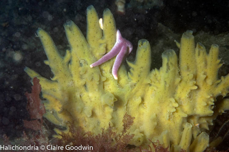
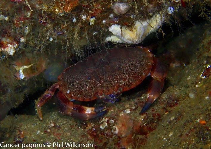
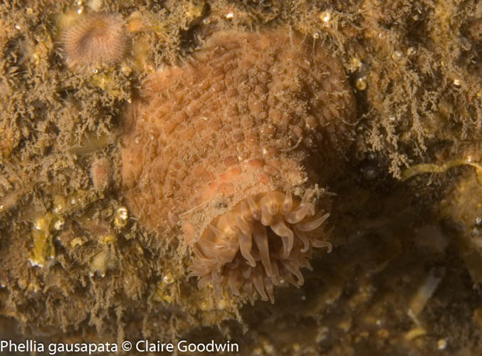
A diverse community of anemones, crustaceans, sponges, soft corals, hydroids, sea squirts and nudibranchs. The non-native invasive red alga species Bonnemaison’s hook weed Bonnemaisonia hamifera has been recorded here.

View all species records from this site

A link to the dive site location on the NBN Atlas Northern Ireland website, showing all species records from within a 1km boundary of the site centroid. Any new species records from the site submitted to Seasearch, iRecord, CEDaR Online Recording or iNaturalist will appear here
Local Charters: A link to the website for the nearest Dive Centre to the site. A map of all dive centres is provided under ‘Go Diving’

North Irish Diver
DV Diving

Environmental and Historical Designations: A list of any environmental or historical designations attributed to the site, or overlapping it. Follow the link for more information

North Channel SAC
Portmuck ASSI

More Information: Links to additional information found online for the dive site

Northern Ireland Marine MapViewer

Safety: Safety tips

  • In an emergency call 999 or 112 and ask for the coastguard.
  • Follow VHF radio Channel 16 (156.8 MHz), the international distress frequency. Send a distress alert followed by ‘MAYDAY, MAYDAY, MAYDAY’ and ‘This is [boat name]’.
  • Find nearest defibrillator (AED) here.
  • Portmuck/Ballylumford Harbour: 028 9336 6666
Latitude, Longitude: The approximate XY coordinates for the dive site in Decimel Degrees (DD). These can be converted to DMS or DDM by following the link below
54.849977, -5.721421

Leave a Comment

Dived here recently? Then let other divers know about this site from your experience!

Leave a Reply

Your email address will not be published. Required fields are marked *

This site uses Akismet to reduce spam. Learn how your comment data is processed.

Join our Mailing List