Wreck Wreck

M.V. Tide

Ballyhornan

Average score: 0

Site name: M.V. Tide
Location: Descriptive location referring to nearest landfall i.e. town, village, harbour or island
Ballyhornan
Type: Describes whether this dive site can be dived from the shore, from a boat, or both
Boat
Wreck: Dive sites which include a shipwreck (or part of a shipwreck) are labelled with a ‘Yes’
Yes
Min. dive depth (m): The approximate minimum depth of the dive given in metres
4
Max. dive depth (m): The approximate maximum depth of the dive given in metres
14

Max. seabed depth (m): The maximum depth of the seabed at the site taken from the intersect between the dive site point and the depth contour on an Admiralty Standard Nautical Chart
14

Diving experience (min level): The recommended minimum level of diving experience for a specific site, described as Novice (<50 dives in temperate/cold waters and minimum certification of PADI Open/Advanced Open Water, BSAC Ocean Diver or CMAS 1 star), Intermediate (50-100 dives in temperate/cold waters and minimum certification of PADI Rescue Dive, BSAC Sports Dive or CMAS 2 star) or Advanced (>250 dives in temperate/cold waters and minimum certification of PADI Divemaster, BSAC Dive Leader or CMAS 3 star
Novice

Optimal wind direction: The general wind direction which causes minimal exposure at the site, corresponding to 8 points of the compass: North (N), North East (NE), East (E, South East (SE), South (S), South West (SW), West, North West (NW)
W/NW/N

Exposure: The approximate level of exposure to wind and wave action at the site on any given day, described as Sheltered (inshore sites surrounded by a form of shelter on all sides), Moderate (sites which are partially sheltered) or Exposed (sites with little to no shelter)
Exposed

Tidal strength: Anecdotal description of tidal strength at the site
Weak

Marine Protected Area: A Yes or No highlighting whether or not the site occurs within a Marine Protected Area
Yes

Visibility: Anecdotal description of the typical underwater visibility at the site
~3-6m
Best time to dive: Anecdotal recommendation for the best time to dive the site for optimal underwater conditions. This typically relates to the stage of the tide
Getting there: Directions for getting to the site

By boat from Ardglass Harbour. The wreck is beneath the shore ~1km SW of Ballyhornan Island.

Facilities: Details of nearest facilities to dive site i.e. public car parking and toilets, slipways etc

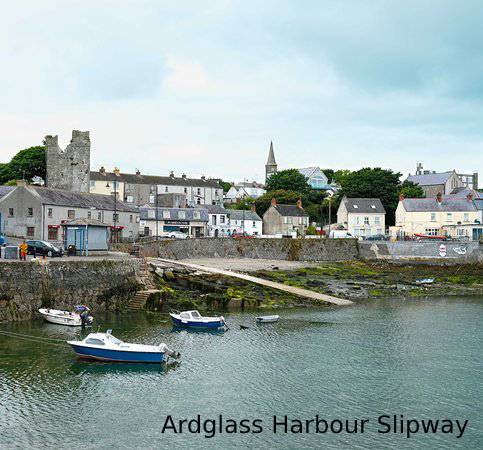
Ardglass provides all weather protection for boats and easy offshore access in most weather conditions. The slipway is 20m long and 4m wide. Contact the harbour master in advance (02844841291/07990648274) as this is a busy fishing harbour. Public toilets can be found at 3 Castle cove in the town and there is car parking at the North Pier on Quay street.

Hazards: Anecdotal information on possible hazards at the site for divers and snorkellers

  • Rusty metal in gullies and metal wires
Description: A general description of the physical features of the dive site

A sloping bedrock wall with boulders up to 2 metres wide, leading down to a seabed of cobbles and pebbles. Much of the superstructure of the ship is buried beneath the sediment, with small fragments of the wreckage scattered on the seabed.

History: The history of the wreck provided by the Senior Marine Archaeologist from the Department for Communities Historic Environment Division (only included for wreck sites)

Date of loss 22/01/1973.

A Dutch Coaster (480 tonnnes), which caught fire 1 mile SSW of Guns Island (IrishWrecksOnline.net)

Biodiversity: A description of the species composition at the site. Species of interest are highlighted. Follow the links for more information about the species on the NBN Atlas Northern Ireland website

The wall supports a kelp park made up of Laminaria hyperborea and dabberlocks Alaria esculenta. The velvet swimming crab Necora puber is common here.

View all species records from this site

A link to the dive site location on the NBN Atlas Northern Ireland website, showing all species records from within a 1km boundary of the site centroid. Any new species records from the site submitted to Seasearch, iRecord, CEDaR Online Recording or iNaturalist will appear here
Local charters: A link to the website for the nearest Dive Centre to the site. A map of all dive centres is provided under ‘Go Diving’

DV Diving

Environmental and Historical Designations: A list of any environmental or historical designations attributed to the site, or overlapping it. Follow the link for more information

Strangford Lough MCZ

More information: Links to additional information found online for the dive site

Northern Ireland Marine MapViewer

Safety: Safety tips

  • In an emergency call 999 or 112 and ask for the coastguard.
  • Follow VHF radio Channel 16 (156.8 MHz), the international distress frequency. Send a distress alert followed by ‘MAYDAY, MAYDAY, MAYDAY’ and ‘This is [boat name]’.
  • Find nearest defibrillator (AED) here.
  • Ardglass Harbour Master: 028 44 841291 / 07990648274
  • When navigating within the harbour/marina, use VHF Channel 12
Latitude, Longitude: The approximate XY coordinates for the dive site in Decimel Degrees (DD). These can be converted to DMS or DDM by following the link below
54.284564, -5.56245

Leave a Comment

Dived here recently? Then let other divers know about this site from your experience!

Leave a Reply

Your email address will not be published. Required fields are marked *

This site uses Akismet to reduce spam. Learn how your comment data is processed.

Join our Mailing List