All Dives Dive

Portrush Harbour

Portrush

Average score: 0

Site name: Portrush Harbour
Location: Descriptive location referring to nearest landfall i.e. town, village, harbour or island
Portrush
Type: Describes whether this dive site can be dived from the shore, from a boat, or both
Shore
Wreck: Dive sites which include a shipwreck (or part of a shipwreck) are labelled with a ‘Yes’
No
Min. dive depth (m): The approximate minimum depth of the dive given in metres
3
Max. dive depth (m): The approximate maximum depth of the dive given in metres
5

Max. seabed depth (m): The maximum depth of the seabed at the site taken from the intersect between the dive site point and the depth contour on an Admiralty Standard Nautical Chart
5

Diving experience (min level): The recommended minimum level of diving experience for a specific site, described as Novice (<50 dives in temperate/cold waters and minimum certification of PADI Open/Advanced Open Water, BSAC Ocean Diver or CMAS 1 star), Intermediate (50-100 dives in temperate/cold waters and minimum certification of PADI Rescue Dive, BSAC Sports Dive or CMAS 2 star) or Advanced (>250 dives in temperate/cold waters and minimum certification of PADI Divemaster, BSAC Dive Leader or CMAS 3 star
Novice

Optimal wind direction: The general wind direction which causes minimal exposure at the site, corresponding to 8 points of the compass: North (N), North East (NE), East (E, South East (SE), South (S), South West (SW), West, North West (NW)
N/NE/E/SE/S/SW/W/NW

Exposure: The approximate level of exposure to wind and wave action at the site on any given day, described as Sheltered (inshore sites surrounded by a form of shelter on all sides), Moderate (sites which are partially sheltered) or Exposed (sites with little to no shelter)
Sheltered

Tidal strength: Anecdotal description of tidal strength at the site
Very weak

Marine Protected Area: A Yes or No highlighting whether or not the site occurs within a Marine Protected Area
No

Visibility: Anecdotal description of the typical underwater visibility at the site
Visibility is poor in the harbour, typically it is around 2-3 metres but can be up to 5 metres.
Best time to dive: Anecdotal recommendation for the best time to dive the site for optimal underwater conditions. This typically relates to the stage of the tide
During the winter only, when boat traffic is minimal. Access easiest nearer HW.
Getting There: Directions for getting to the site

Park at Portrush Harbour car park (if you can find a space!). Enter the water from the slipway or pontoons (access code required) and dive beneath the north harbour wall. Important to get permission from the Harbour Master prior to dive: 02870822307./ 0788981860

Facilities: Details of nearest facilities to dive site i.e. public car parking and toilets, slipways etc

Portrush Harbour offers free car parking above the harbour, public toilets in the harbour office and a slipway on the North Pier. There is a barrier to the harbour which is staffed during office hours, 7 days a week from April – September. Fees apply; for use contact Portrush Harbour Office: 02870822307 / 0788981860.

Nearest tank filling is Aquaholics in Portstewart (028 7083 2584)

Hazards: Anecdotal information on possible hazards at the site for divers and snorkellers

  • Boat traffic, especially in the summer months, therefore this site is only safe to dive in the winter.
  • DSMB and shore cover with an ‘A’ flag required as well as permission from Harbour Master prior to dive (Tel: 02870822307).
  • Be mindful of RNLI station in the harbour.
  • Litter is abundant at this site with bottles, cans, fishing lines, tool equipment and chains.
Description: A general description of the physical features of the dive site

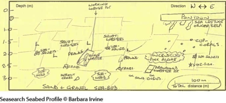
The north harbour wall has large crevices which descend to a fine silt and sandy seabed (with some gravel areas). Litter is abundant at this site.

Biodiversity: A description of the species composition at the site. Species of interest are highlighted. Follow the links for more information about the species on the NBN Atlas Northern Ireland website

The harbour wall is covered in green sea lettuce and sugar kelp, with patches of red algae, Devonshire cup corals, encrusting pink algae and sea squirts. A number of invasive species have been recorded in the harbour such as the orange tipped sea squirt Corella eumyota, the bryozoan Tricellaria inopinata, the red algae Dasysiphonia japonica and the amphipod Monocorophium insidiosum.

View all species records from this site

A link to the dive site location on the NBN Atlas Northern Ireland website, showing all species records from within a 1km boundary of the site centroid. Any new species records from the site submitted to Seasearch, iRecord, CEDaR Online Recording or iNaturalist will appear here
Local Charters: A link to the website for the nearest Dive Centre to the site. A map of all dive centres is provided under ‘Go Diving’

Aquaholics

Environmental and Historical Designations: A list of any environmental or historical designations attributed to the site, or overlapping it. Follow the link for more information

More Information: Links to additional information found online for the dive site

Northern Ireland Marine MapViewer

Safety: Safety tips

  • In an emergency call 999 or 112 and ask for the coastguard.
  • Follow VHF radio Channel 16 (156.8 MHz), the international distress frequency.
  • Find nearest defibrillator (AED) here
  • Portrush Harbour Office: 02870822307
Latitude, Longitude: The approximate XY coordinates for the dive site in Decimel Degrees (DD). These can be converted to DMS or DDM by following the link below
55.206185, -6.659480

Leave a Comment

Dived here recently? Then let other divers know about this site from your experience!

Leave a Reply

Your email address will not be published. Required fields are marked *

This site uses Akismet to reduce spam. Learn how your comment data is processed.

Join our Mailing List