Location:Descriptive location referring to nearest landfall i.e. town, village, harbour or island
Outer Ards Peninsula
Type:Describes whether this dive site can be dived from the shore, from a boat, or both
Boat
Wreck:Dive sites which include a shipwreck (or part of a shipwreck) are labelled with a ‘Yes’
Yes
Min. dive depth (m):The approximate minimum depth of the dive given in metres
Max. dive depth (m):The approximate maximum depth of the dive given in metres
5
Max. seabed depth (m):The maximum depth of the seabed at the site taken from the intersect between the dive site point and the depth contour on an Admiralty Standard Nautical Chart
6
Diving experience (min level):The recommended minimum level of diving experience for a specific site, described as Novice (<50 dives in temperate/cold waters and minimum certification of PADI Open/Advanced Open Water, BSAC Ocean Diver or CMAS 1 star), Intermediate (50-100 dives in temperate/cold waters and minimum certification of PADI Rescue Dive, BSAC Sports Dive or CMAS 2 star) or Advanced (>250 dives in temperate/cold waters and minimum certification of PADI Divemaster, BSAC Dive Leader or CMAS 3 star
Novice
Optimal wind direction:The general wind direction which causes minimal exposure at the site, corresponding to 8 points of the compass: North (N), North East (NE), East (E, South East (SE), South (S), South West (SW), West, North West (NW)
SW/W/NW
Exposure:The approximate level of exposure to wind and wave action at the site on any given day, described as Sheltered (inshore sites surrounded by a form of shelter on all sides), Moderate (sites which are partially sheltered) or Exposed (sites with little to no shelter)
Exposed
Tidal strength:Anecdotal description of tidal strength at the site
Marine Protected Area:A Yes or No highlighting whether or not the site occurs within a Marine Protected Area
No
Visibility:Anecdotal description of the typical underwater visibility at the site
5-10m
Best time to dive:Anecdotal recommendation for the best time to dive the site for optimal underwater conditions. This typically relates to the stage of the tide
Getting there:Directions for getting to the site
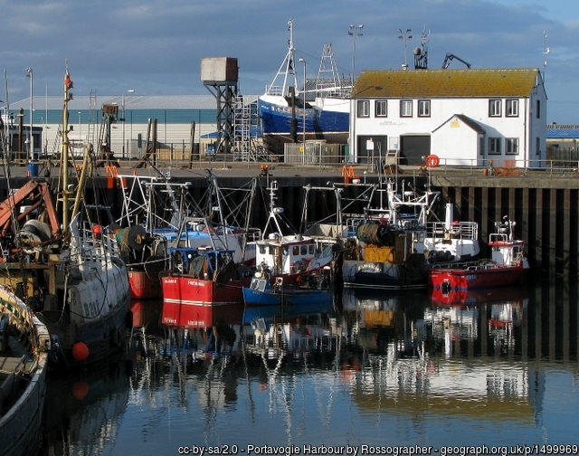
By boat launch from Portavogie. The wreck lies ~2km SE of Kearney Point.
Facilities:Details of nearest facilities to dive site i.e. public car parking and toilets, slipways etc
Portavogie harbour offers complete protection from all conditions and access is easy at all tides. Contact the harbour master for guidance and berthing availability: Tel: 028 9188 2377. Diesel is available at the wharfs. Public toilets are available near Anchor car park.
Nearest tank filling is DV Diving, Newtownards.
Hazards:Anecdotal information on possible hazards at the site for divers and snorkellers
Description:A general description of the physical features of the dive site
The wreck is 10m high and broken into sections, with scattered plates around the site. The seabed consists of sand and rocks.
History:The history of the wreck provided by the Senior Marine Archaeologist from the Department for Communities Historic Environment Division (only included for wreck sites)
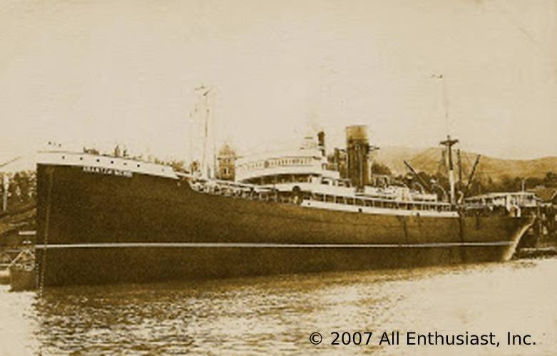
Date of loss 09/05/1939. Spanish steamship (Steel; LBD 120.7 x 16.89 x 10.46; GT 6646). En route from Bougie to Glasgow carrying iron ore when ran ashore. The cargo was later discharged and salvaged. Part of the wreck was exposed at low water. (Sources: Larn & Larn 2002).
Information derived from Historic Environment Record of Northern Ireland (HERoNI), Department for Communities, Historic Environment Division.
Biodiversity:A description of the species composition at the site. Species of interest are highlighted. Follow the links for more information about the species on the NBN Atlas Northern Ireland website
The wreck is partially covered in dead men’s fingers Alcyonium digitatum and several anemone species. Mixed brown and red algae dominate the adjacent rocky reef.
A link to the dive site location on the NBN Atlas Northern Ireland website, showing all species records from within a 1km boundary of the site centroid. Any new species records from the site submitted to Seasearch, iRecord, CEDaR Online Recording or iNaturalist will appear here
Local charters:A link to the website for the nearest Dive Centre to the site. A map of all dive centres is provided under ‘Go Diving’
Environmental and Historical Designations:A list of any environmental or historical designations attributed to the site, or overlapping it. Follow the link for more information
More information:Links to additional information found online for the dive site
In an emergency call 999 or 112 and ask for the coastguard.
Follow VHF radio Channel 16 (156.8 MHz), the international distress frequency. Send a distress alert followed by ‘MAYDAY, MAYDAY, MAYDAY’ and ‘This is [boat name]’.
Latitude, Longitude:The approximate XY coordinates for the dive site in Decimel Degrees (DD). These can be converted to DMS or DDM by following the link below


Leave a Comment
Dived here recently? Then let other divers know about this site from your experience!