Wreck Wreck

S.S. Connemara

Carlingford Lough

Average score: 0

Site name: S.S. Connemara
Location: Descriptive location referring to nearest landfall i.e. town, village, harbour or island
Carlingford Lough
Type: Describes whether this dive site can be dived from the shore, from a boat, or both
Boat
Wreck: Dive sites which include a shipwreck (or part of a shipwreck) are labelled with a ‘Yes’
Yes
Min. dive depth (m): The approximate minimum depth of the dive given in metres
3
Max. dive depth (m): The approximate maximum depth of the dive given in metres
6

Max. seabed depth (m): The maximum depth of the seabed at the site taken from the intersect between the dive site point and the depth contour on an Admiralty Standard Nautical Chart
6

Diving experience (min level): The recommended minimum level of diving experience for a specific site, described as Novice (<50 dives in temperate/cold waters and minimum certification of PADI Open/Advanced Open Water, BSAC Ocean Diver or CMAS 1 star), Intermediate (50-100 dives in temperate/cold waters and minimum certification of PADI Rescue Dive, BSAC Sports Dive or CMAS 2 star) or Advanced (>250 dives in temperate/cold waters and minimum certification of PADI Divemaster, BSAC Dive Leader or CMAS 3 star
Novice

Optimal wind direction: The general wind direction which causes minimal exposure at the site, corresponding to 8 points of the compass: North (N), North East (NE), East (E, South East (SE), South (S), South West (SW), West, North West (NW)
W/NW/N

Exposure: The approximate level of exposure to wind and wave action at the site on any given day, described as Sheltered (inshore sites surrounded by a form of shelter on all sides), Moderate (sites which are partially sheltered) or Exposed (sites with little to no shelter)
Exposed

Tidal strength: Anecdotal description of tidal strength at the site

Marine Protected Area: A Yes or No highlighting whether or not the site occurs within a Marine Protected Area
Yes

Visibility: Anecdotal description of the typical underwater visibility at the site
Visibility averages around 5-10 metres
Best time to dive: Anecdotal recommendation for the best time to dive the site for optimal underwater conditions. This typically relates to the stage of the tide
Slack water
Getting there: Directions for getting to the site

By boat from Carlingford. The wreck lies approx. 500m south of Cranfield Point.

Facilities: Details of nearest facilities to dive site i.e. public car parking and toilets, slipways etc

Carlingford Marina provides facilities including a slip, pontoons and toilets (visit: https://www.carlingfordmarina.com/). Public toilets are also available near to the western pier in Carlingford.

Small boats can be launched from the shore at Greenore. Free car parking is available above the launch site: https://goo.gl/maps/Xv6PPocjis3ftBMP9 The nearest public toilets are in Carlingford village.

Hazards: Anecdotal information on possible hazards at the site for divers and snorkellers

  • Strong currents.
  • The site lies close to the main shipping channel.
Description: A general description of the physical features of the dive site

Little of the wreck remains but this is a nice dive with plenty of life.

History: The history of the wreck provided by the Senior Marine Archaeologist from the Department for Communities Historic Environment Division (only included for wreck sites)

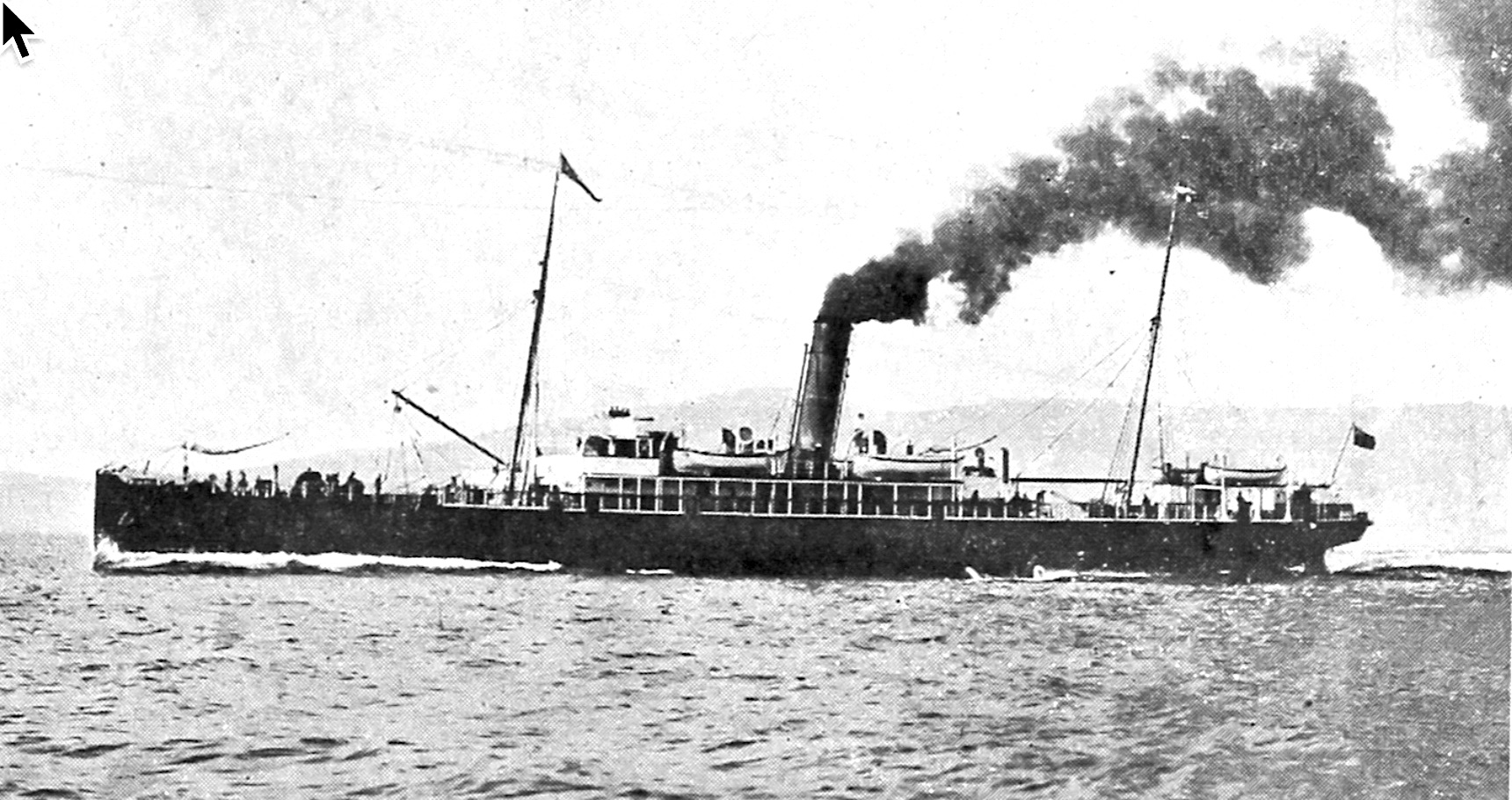
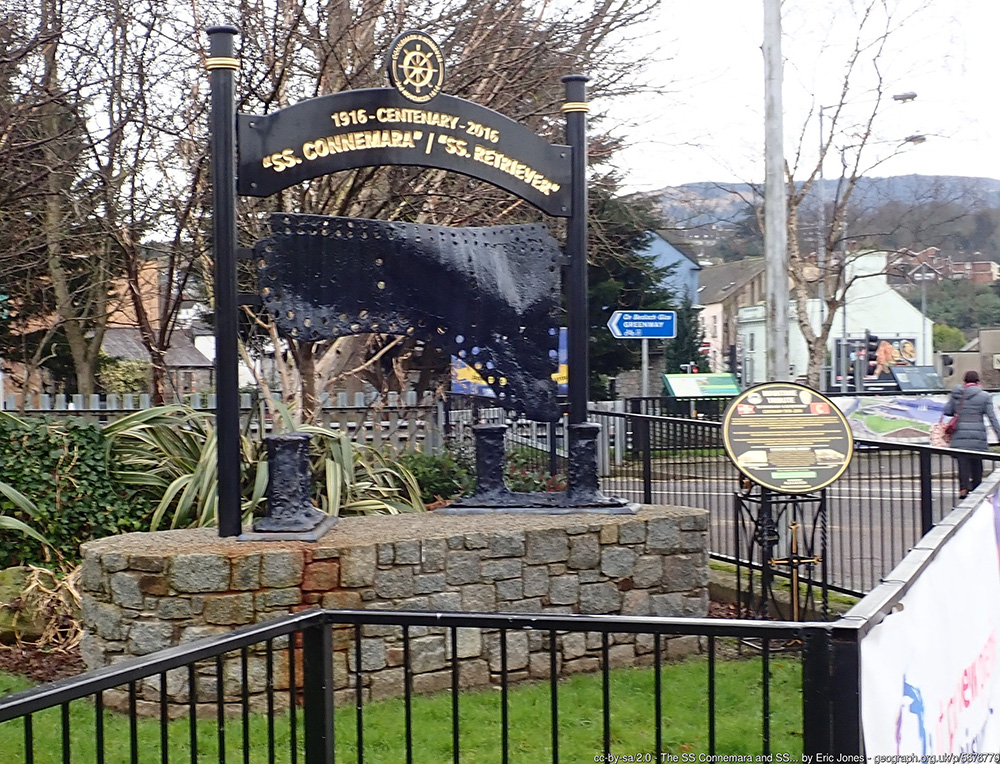
Date of loss 03/11/1916. Built 1897 Dumbarton. Passenger/cargo steamship en route from Greenore to Holyhead carrying 51 passengers and 30 crew. Cargo of cattle. Struck amidships by the collier SS Retriever. The Connemara sank within 10 minutes with the loss of all aboard. The Retriever also sank with only one survivor. (Larn & Larn 2002).

Information derived from Historic Environment Record of Northern Ireland (HERoNI), Department for Communities, Historic Environment Division.

Biodiversity: A description of the species composition at the site. Species of interest are highlighted. Follow the links for more information about the species on the NBN Atlas Northern Ireland website

Not yet described!

View all species records from this site

A link to the dive site location on the NBN Atlas Northern Ireland website, showing all species records from within a 1km boundary of the site centroid. Any new species records from the site submitted to Seasearch, iRecord, CEDaR Online Recording or iNaturalist will appear here
Local charters: A link to the website for the nearest Dive Centre to the site. A map of all dive centres is provided under ‘Go Diving’

Louth Adventures

Environmental and Historical Designations: A list of any environmental or historical designations attributed to the site, or overlapping it. Follow the link for more information

Carlingford Lough SPA

More information: Links to additional information found online for the dive site

Irish Wrecks Online
Wreck Site

Safety: Safety tips

  • In an emergency call 999 or 112 and ask for the coastguard.
  • Follow VHF radio Channel 16 (156.8 MHz), the international distress frequency. Send a distress alert followed by ‘MAYDAY, MAYDAY, MAYDAY’ and ‘This is [boat name]’.
  • Find nearest defibrillator (AED) here
  • Carlingford Marina: +353 42 937 3072 . When navigating within the harbour/marina, use VHF Channel 37 (M1)
Latitude, Longitude: The approximate XY coordinates for the dive site in Decimel Degrees (DD). These can be converted to DMS or DDM by following the link below
54.0178, -6.061283

Leave a Comment

Dived here recently? Then let other divers know about this site from your experience!

Leave a Reply

Your email address will not be published. Required fields are marked *

This site uses Akismet to reduce spam. Learn how your comment data is processed.

Join our Mailing List