Location:Descriptive location referring to nearest landfall i.e. town, village, harbour or island
Larne
Type:Describes whether this dive site can be dived from the shore, from a boat, or both
Boat
Wreck:Dive sites which include a shipwreck (or part of a shipwreck) are labelled with a ‘Yes’
Yes
Min. dive depth (m):The approximate minimum depth of the dive given in metres
10
Max. dive depth (m):The approximate maximum depth of the dive given in metres
35
Max. seabed depth (m):The maximum depth of the seabed at the site taken from the intersect between the dive site point and the depth contour on an Admiralty Standard Nautical Chart
65
Diving experience (min level):The recommended minimum level of diving experience for a specific site, described as Novice (<50 dives in temperate/cold waters and minimum certification of PADI Open/Advanced Open Water, BSAC Ocean Diver or CMAS 1 star), Intermediate (50-100 dives in temperate/cold waters and minimum certification of PADI Rescue Dive, BSAC Sports Dive or CMAS 2 star) or Advanced (>250 dives in temperate/cold waters and minimum certification of PADI Divemaster, BSAC Dive Leader or CMAS 3 star
Advanced
Optimal wind direction:The general wind direction which causes minimal exposure at the site, corresponding to 8 points of the compass: North (N), North East (NE), East (E, South East (SE), South (S), South West (SW), West, North West (NW)
SW/W
Exposure:The approximate level of exposure to wind and wave action at the site on any given day, described as Sheltered (inshore sites surrounded by a form of shelter on all sides), Moderate (sites which are partially sheltered) or Exposed (sites with little to no shelter)
Exposed
Tidal strength:Anecdotal description of tidal strength at the site
Strong
Marine Protected Area:A Yes or No highlighting whether or not the site occurs within a Marine Protected Area
Yes
Visibility:Anecdotal description of the typical underwater visibility at the site
Visibility ranges from 5-10 metres
Best time to dive:Anecdotal recommendation for the best time to dive the site for optimal underwater conditions. This typically relates to the stage of the tide
Slack water only as currents can be strong in this area. Slack water is 1 hour before HW/LW Belfast
Getting there:Directions for getting to the site
By boat from Portmuck or Ballylumford Harbour, travel 6.5 km north-east towards the Maidens. The site is on the north side of Russells Rock.
Facilities:Details of nearest facilities to dive site i.e. public car parking and toilets, slipways etc
Portmuck Harbour provides free car parking, a slipway and public toilets. The pier is 25 metres long, 6.5 metres wide and in good condition.
Free parking, a slipway, public toilets and outdoor changing facilities are available at Ballylumford Harbour as well (access to slipway restricted to Islandmagee Boat Club members; email: info@islandmageeboatclub.co.uk).
Nearest tank filling is DV Diving, Mount Stewart, Newtownards.
Hazards:Anecdotal information on possible hazards at the site for divers and snorkellers
Current can be very strong in area.
Be mindful of rocks just below the surface in the area.
Usual hazards associated with wrecks, including some deterioration.
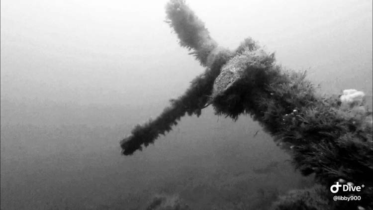
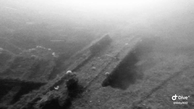
Description:A general description of the physical features of the dive site
Wreck lies just off Russell Rock, to the north-east. The wreck is badly broken up but it is huge – the largest at the Maidens. It is possible to follow a trail of broken metal down to 30 metres, where you can see the boiler and as you descend you will notice a sloping wall on your right that drops to around 45 metres. There is a nice rocky reef beneath Russell Rock at ~35metres.
History:The history of the wreck provided by the Senior Marine Archaeologist from the Department for Communities Historic Environment Division (only included for wreck sites)
Date of loss 04/01/1908. A steel tanker en route from Barrow-in-Furness to New York in ballast. LBD: 105.86 x 13.86 x 8.28; g.t. 4041. Built in 1893 by Naval Construction and Armament Co, and owned by Anglo-American Oil Co. of London. Having left Barrow on 3rd January 1908 she struck Russell Rock, on her port side, and started to take on water. The Captain ordered all the crew off but the officers, who remained. Rockets were sent up but very unluckily one fell back onto the ship and started a fire. All but two crew members made it off the ship; one falling in when he tried to board a lifeboat and another was noticed missing as they neared the lighthouses. It took them three hours to make it to the lighthouse. The surviving crew were collected from there 24 hours later. (Sources: Larn & Larn 2002; Ms. L. Keatley).
Information derived from Historic Environment Record of Northern Ireland (HERoNI), Department for Communities, Historic Environment Division.
Biodiversity:A description of the species composition at the site. Species of interest are highlighted. Follow the links for more information about the species on the NBN Atlas Northern Ireland website
The wreck is covered in intermittent patches of dead men’s fingers, anemones, urchins and short animal turf.
A link to the dive site location on the NBN Atlas Northern Ireland website, showing all species records from within a 1km boundary of the site centroid. Any new species records from the site submitted to Seasearch, iRecord, CEDaR Online Recording or iNaturalist will appear here
Local charters:A link to the website for the nearest Dive Centre to the site. A map of all dive centres is provided under ‘Go Diving’
Environmental and Historical Designations:A list of any environmental or historical designations attributed to the site, or overlapping it. Follow the link for more information
In an emergency call 999 or 112 and ask for the coastguard.
Follow VHF radio Channel 16 (156.8 MHz), the international distress frequency. Send a distress alert followed by ‘MAYDAY, MAYDAY, MAYDAY’ and ‘This is [boat name]’.
Latitude, Longitude:The approximate XY coordinates for the dive site in Decimel Degrees (DD). These can be converted to DMS or DDM by following the link below


Leave a Comment
Dived here recently? Then let other divers know about this site from your experience!