Wreck Wreck

S.S. Templemore

Ballycastle

Average score: 0

Site name: S.S. Templemore
Location: Descriptive location referring to nearest landfall i.e. town, village, harbour or island
Ballycastle
Type: Describes whether this dive site can be dived from the shore, from a boat, or both
Boat
Wreck: Dive sites which include a shipwreck (or part of a shipwreck) are labelled with a ‘Yes’
Yes
Min. dive depth (m): The approximate minimum depth of the dive given in metres
13.4
Max. dive depth (m): The approximate maximum depth of the dive given in metres
22

Max. seabed depth (m): The maximum depth of the seabed at the site taken from the intersect between the dive site point and the depth contour on an Admiralty Standard Nautical Chart
22

Diving experience (min level): The recommended minimum level of diving experience for a specific site, described as Novice (<50 dives in temperate/cold waters and minimum certification of PADI Open/Advanced Open Water, BSAC Ocean Diver or CMAS 1 star), Intermediate (50-100 dives in temperate/cold waters and minimum certification of PADI Rescue Dive, BSAC Sports Dive or CMAS 2 star) or Advanced (>250 dives in temperate/cold waters and minimum certification of PADI Divemaster, BSAC Dive Leader or CMAS 3 star
Intermediate

Optimal wind direction: The general wind direction which causes minimal exposure at the site, corresponding to 8 points of the compass: North (N), North East (NE), East (E, South East (SE), South (S), South West (SW), West, North West (NW)
SE/S/SW/W

Exposure: The approximate level of exposure to wind and wave action at the site on any given day, described as Sheltered (inshore sites surrounded by a form of shelter on all sides), Moderate (sites which are partially sheltered) or Exposed (sites with little to no shelter)
Exposed

Tidal strength: Anecdotal description of tidal strength at the site

Marine Protected Area: A Yes or No highlighting whether or not the site occurs within a Marine Protected Area
No

Visibility: Anecdotal description of the typical underwater visibility at the site
Best time to dive: Anecdotal recommendation for the best time to dive the site for optimal underwater conditions. This typically relates to the stage of the tide
First hour of ebb tide Ballycastle
Getting there: Directions for getting to the site

By boat launch from Ballycastle, travel north-east for approx. 500 metres (there is no longer a buoy marking the site).

Facilities: Details of nearest facilities to dive site i.e. public car parking and toilets, slipways etc

Ballycastle Harbour has a gated slipway (open during office hours) and pontoon berthing (fees apply). For use contact the Ballycastle Harbour Office: 02820768525 / 07803505984. Free car parking is available above the harbour and marina. Free public toilets are available in the visitor information office above the harbour.

Nearest tank filling is Aquaholics in Ballycastle or Portstewart (ring ahead: 028 7083 2584)

Hazards: Anecdotal information on possible hazards at the site for divers and snorkellers

  • The wreck is well broken up with sharp edges.
  • The site is close to recreational boating activity out of Ballycastle Harbour and the Ballycastle to Rathlin ferry line.
Description: A general description of the physical features of the dive site

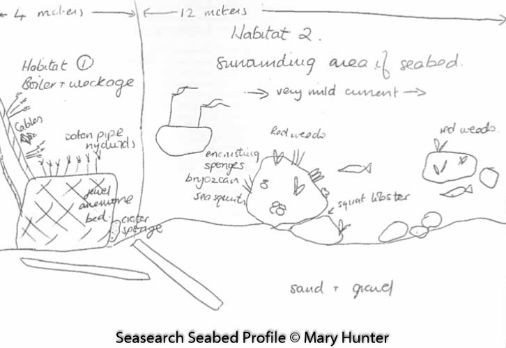
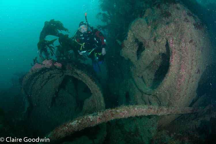
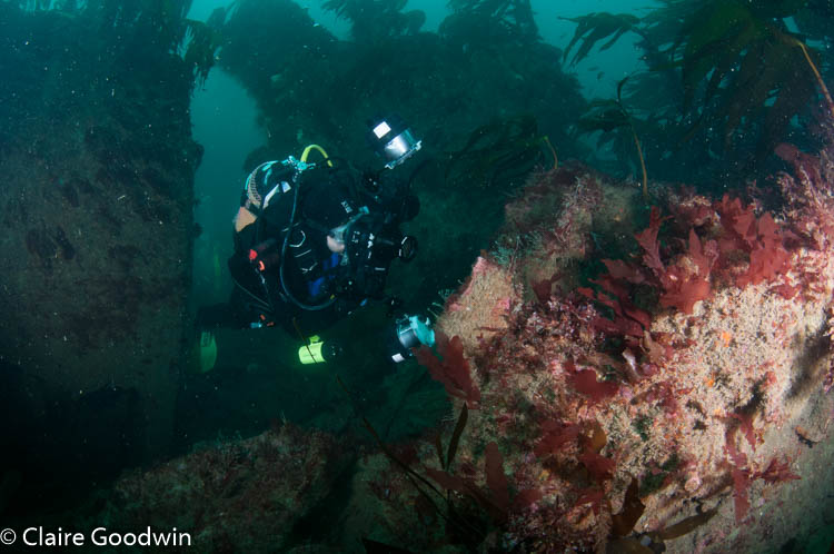
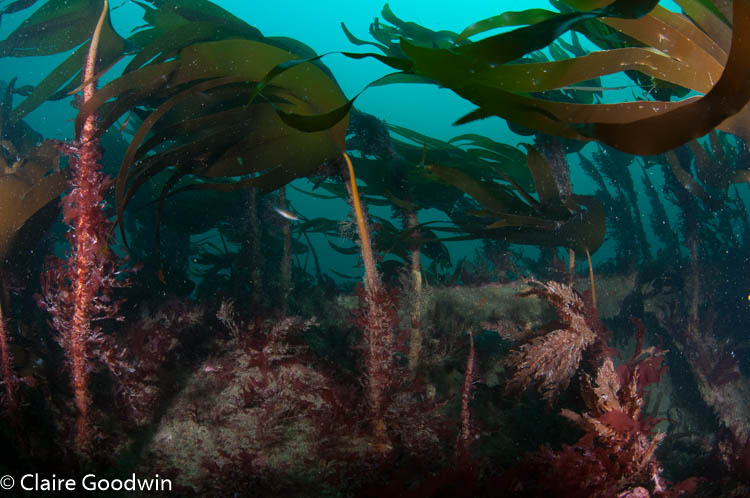
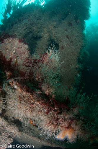
The wreck is laying inverted and is well broken up. It lies on a coarse sand and mixed sediment seabed covered in kelp park.

History: The history of the wreck provided by the Senior Marine Archaeologist from the Department for Communities Historic Environment Division (only included for wreck sites)

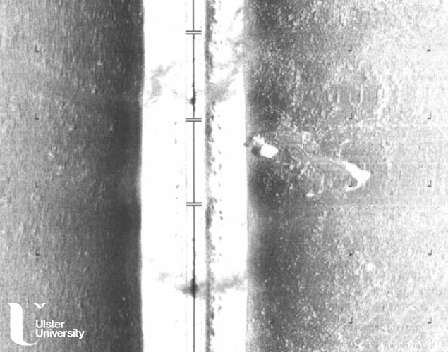
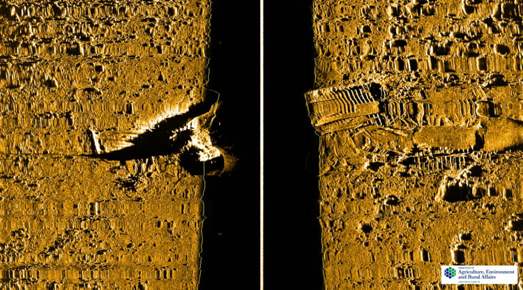
Date of loss 06/12/1911. This 386 gross ton British Coaster sank 300m east of Ballycastle harbour after it listed and capsized. Two lives were lost and nine lives saved. The vessel was built by J. Fullerton and Co., Paisley in 1905, and owned by Henry Lane & Co., Londonderry. It had a length of 145 ft., a breadth of 24 ft. and a depth/draught of 8 ft. Its voyage was from Ellesmere Port to Londonderry carrying a cargo of coal. On 4th December heavy seas had flooded the engine room, extinguishing the fires, and the Templemore had to anchor in Murlough Bay. Two of the crew rowed ashore and sought assistance. The tug Earl of Dunraven was sent out, taking an engineer, Charles Maude, who boarded the Coaster. The vessels proceeded to Ballycastle, but the Templemore, which had been listing, capsized and sank. Maude and the ship’s engineer, John Simms were lost. The captain, George Butler, and remaining crew were rescued by three Ballycastle fishermen, John Coyle, William Robinson and Donald Black. The wreckage is mostly collapsed and lies in a general depth of 19-20m. (Sources: AWD; Cecil, The Harsh Winds of Rathlin p.72-3; WA G87).

Information derived from Historic Environment Record of Northern Ireland (HERoNI), Department for Communities, Historic Environment Division.

Biodiversity: A description of the species composition at the site. Species of interest are highlighted. Follow the links for more information about the species on the NBN Atlas Northern Ireland website

Much of the wreck and surrounding seabed are covered in patches of kelp. bow of the wreck is covered in patches of kelp. Dense colonies of Dead man’s fingers Alcyonium digitatum and hydroids are also found on the wreck. The European spiny lobster (crawfish) Palinurus elephas, a Northern Ireland Priority Species, has also been recorded on the wreck.

View all species records from this site

A link to the dive site location on the NBN Atlas Northern Ireland website, showing all species records from within a 1km boundary of the site centroid. Any new species records from the site submitted to Seasearch, iRecord, CEDaR Online Recording or iNaturalist will appear here
Local charters: A link to the website for the nearest Dive Centre to the site. A map of all dive centres is provided under ‘Go Diving’

Aquaholics

Environmental and Historical Designations: A list of any environmental or historical designations attributed to the site, or overlapping it. Follow the link for more information

More information: Links to additional information found online for the dive site

Irish Wrecks Online
Irish Shipwrecks
Northern Ireland Marine MapViewer

Safety: Safety tips

  • In an emergency call 999 or 112 and ask for the coastguard.
  • Follow VHF radio Channel 16 (156.8 MHz), the international distress frequency. Send a distress alert followed by ‘MAYDAY, MAYDAY, MAYDAY’ and ‘This is [boat name]’.
  • Find nearest defibrillator (AED) here.
  • Ballycastle Harbour Office No. 028 207 68525 Mobile Number 07803 505084
  • When navigating within Ballycastle Harbour, use VHF Channel 80.
Latitude, Longitude: The approximate XY coordinates for the dive site in Decimel Degrees (DD). These can be converted to DMS or DDM by following the link below
55.211433, -6.231867

Watch more videos from the Templemore wreck

Leave a Comment

Dived here recently? Then let other divers know about this site from your experience!

Leave a Reply

Your email address will not be published. Required fields are marked *

This site uses Akismet to reduce spam. Learn how your comment data is processed.

Join our Mailing List