All Dives Dive

Shamrock Pinnacle

Ballycastle

Average score: 0

Site name: Shamrock Pinnacle
Location: Descriptive location referring to nearest landfall i.e. town, village, harbour or island
Ballycastle
Type: Describes whether this dive site can be dived from the shore, from a boat, or both
Boat
Wreck: Dive sites which include a shipwreck (or part of a shipwreck) are labelled with a ‘Yes’
No
Min. dive depth (m): The approximate minimum depth of the dive given in metres
15
Max. dive depth (m): The approximate maximum depth of the dive given in metres
40

Max. seabed depth (m): The maximum depth of the seabed at the site taken from the intersect between the dive site point and the depth contour on an Admiralty Standard Nautical Chart
119

Diving experience (min level): The recommended minimum level of diving experience for a specific site, described as Novice (<50 dives in temperate/cold waters and minimum certification of PADI Open/Advanced Open Water, BSAC Ocean Diver or CMAS 1 star), Intermediate (50-100 dives in temperate/cold waters and minimum certification of PADI Rescue Dive, BSAC Sports Dive or CMAS 2 star) or Advanced (>250 dives in temperate/cold waters and minimum certification of PADI Divemaster, BSAC Dive Leader or CMAS 3 star
Advanced

Optimal wind direction: The general wind direction which causes minimal exposure at the site, corresponding to 8 points of the compass: North (N), North East (NE), East (E, South East (SE), South (S), South West (SW), West, North West (NW)
S/SW

Exposure: The approximate level of exposure to wind and wave action at the site on any given day, described as Sheltered (inshore sites surrounded by a form of shelter on all sides), Moderate (sites which are partially sheltered) or Exposed (sites with little to no shelter)
Exposed

Tidal strength: Anecdotal description of tidal strength at the site
Strong

Marine Protected Area: A Yes or No highlighting whether or not the site occurs within a Marine Protected Area
No

Visibility: Anecdotal description of the typical underwater visibility at the site
Normally very good
Best time to dive: Anecdotal recommendation for the best time to dive the site for optimal underwater conditions. This typically relates to the stage of the tide
HW or LW Slack (15-20 minute window eitherside of both)
Getting There: Directions for getting to the site

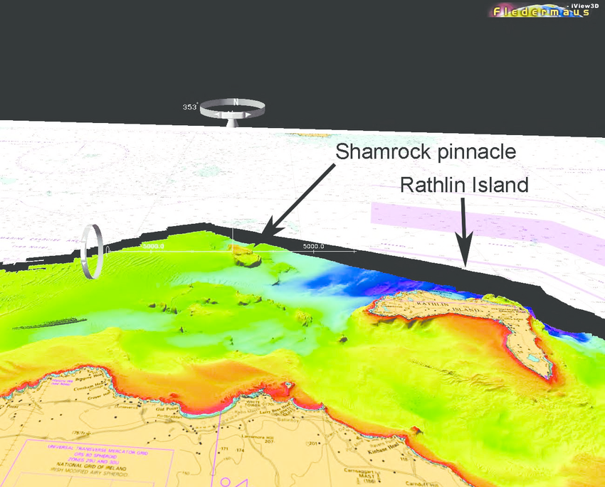
By boat from Ballycastle. The Shamrock Pinnacle is found approx. 10km north west of Bull Point, Rathlin Island.

Facilities: Details of nearest facilities to dive site i.e. public car parking and toilets, slipways etc

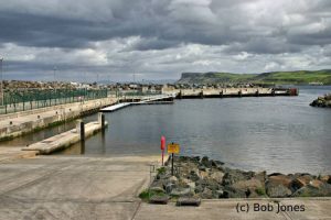
Ballycastle Harbour has a gated slipway (open during office hours) and pontoon berthing (fees apply). For use contact the Ballycastle Harbour Office: 02820768525 / 07803505984. Free car parking is available above the harbour and marina. Free public toilets are available in the visitor information office above the harbour.

Nearest tank filling is Aquaholics in Ballycastle or Portstewart (ring ahead: 028 7083 2584)

Hazards: Anecdotal information on possible hazards at the site for divers and snorkellers

  • Very strong tides that can easilly sweep divers off the pinnacle if the dive is mistimed.
  • Small pinnacle with steep walls on all sides – divers must have delayed surface marker buoys and other signalling equipment.
  • Vigilant boat cover required as tide likely to be running when divers are ascending.
  • Divers should be comfortable with free ascents and doing safety/deco stops while drifting.
  • The pinnacle should be shotted prior to the dive to ensure that the desired depth is obtained, to check the tidal flow and to provide a reference point for divers.
Description: A general description of the physical features of the dive site

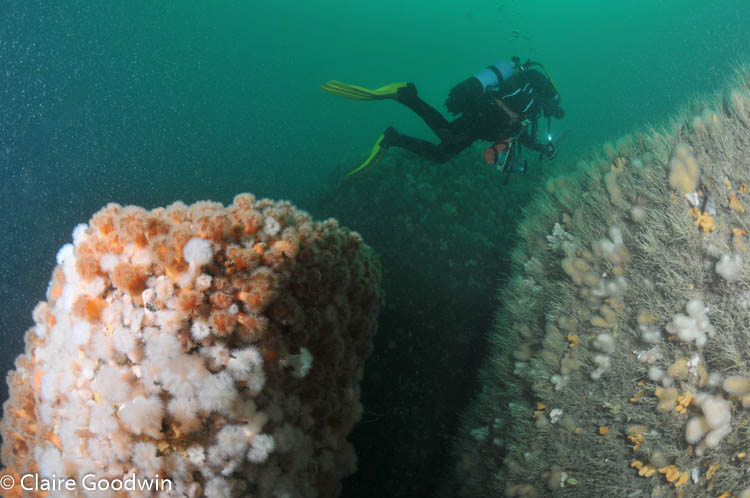
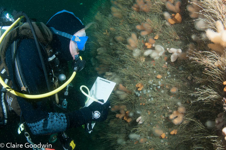
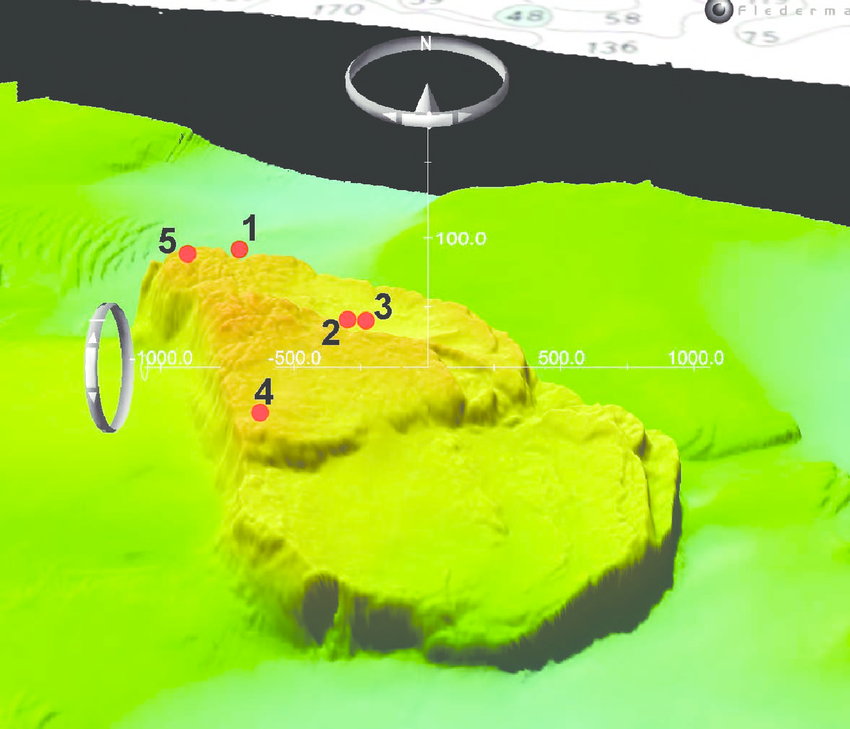
Shamrock Pinnacle is one of a series of submerged pinnacles lying between Scotland and Northern Ireland. It is approximately 10km north-west of Rathlin Island. The minimum depth of the pinnacle is 15 m below chart datum (BCD) with the majority being deeper than 30 m. The north side of the pinnacle is a sheer wall which drops to over 140 m, the south and east faces slopes more gradually to around 75 m before a similarly sheer wall. The pinnacle is situated in the full flow of the North Channel tidal stream, experiencing up to 3 knots of tidal current on spring tides. At the position given (on the north-west corner) there is a small stack which is covered in plumose anemones. Information about diving around Shamrock Pinnacle is available from the Shamrock Pinnacle Survey Report 2009-2011 

Biodiversity: A description of the species composition at the site. Species of interest are highlighted. Follow the links for more information about the species on the NBN Atlas Northern Ireland website

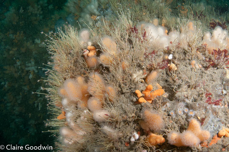
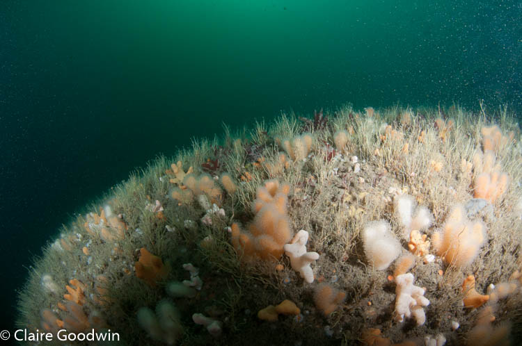
The bedrock of the pinnacle is strongly tide-swept. It is dominated by hardy species such as the oaten pipe hydroid Tubularia indivisa, dead men’s fingers Alcyonium digitatum, and the elephant hide sponge Pachymatisma johnstonia. Species of particular interest include the sea squirt Synoicum incrustatum and the white cluster anemone Parazoanthus anguicomus

View all species records from this site

A link to the dive site location on the NBN Atlas Northern Ireland website, showing all species records from within a 1km boundary of the site centroid. Any new species records from the site submitted to Seasearch, iRecord, CEDaR Online Recording or iNaturalist will appear here
Local Charters: A link to the website for the nearest Dive Centre to the site. A map of all dive centres is provided under ‘Go Diving’

Aquaholics

Environmental and Historical Designations: A list of any environmental or historical designations attributed to the site, or overlapping it. Follow the link for more information

More Information: Links to additional information found online for the dive site

Shamrock Pinnacle Survey Report 2009-2011

Northern Ireland Marine MapViewer

Safety: Safety tips

  • In an emergency call 999 or 112 and ask for the coastguard.
  • Follow VHF radio Channel 16 (156.8 MHz), the international distress frequency. Send a distress alert followed by ‘MAYDAY, MAYDAY, MAYDAY’ and ‘This is [boat name]’.
  • Find nearest defibrillator (AED) here.
  • Ballycastle Harbour Office No. 028 207 68525 Mobile Number 07803 505084
  • When navigating within Ballycastle Harbour, use VHF Channel 80.
Latitude, Longitude: The approximate XY coordinates for the dive site in Decimel Degrees (DD). These can be converted to DMS or DDM by following the link below
55.35338, -6.40103

Leave a Comment

Dived here recently? Then let other divers know about this site from your experience!

Leave a Reply

Your email address will not be published. Required fields are marked *

This site uses Akismet to reduce spam. Learn how your comment data is processed.

Join our Mailing List