Wreck Wreck

S.V. Nimble ‘The Pins’

Strangford Lough

Average score: 0

Site name: S.V. Nimble ‘The Pins’
Location: Descriptive location referring to nearest landfall i.e. town, village, harbour or island
Strangford Lough
Type: Describes whether this dive site can be dived from the shore, from a boat, or both
Shore
Wreck: Dive sites which include a shipwreck (or part of a shipwreck) are labelled with a ‘Yes’
Yes
Min. dive depth (m): The approximate minimum depth of the dive given in metres
1
Max. dive depth (m): The approximate maximum depth of the dive given in metres
10

Max. seabed depth (m): The maximum depth of the seabed at the site taken from the intersect between the dive site point and the depth contour on an Admiralty Standard Nautical Chart
11.7

Diving experience (min level): The recommended minimum level of diving experience for a specific site, described as Novice (<50 dives in temperate/cold waters and minimum certification of PADI Open/Advanced Open Water, BSAC Ocean Diver or CMAS 1 star), Intermediate (50-100 dives in temperate/cold waters and minimum certification of PADI Rescue Dive, BSAC Sports Dive or CMAS 2 star) or Advanced (>250 dives in temperate/cold waters and minimum certification of PADI Divemaster, BSAC Dive Leader or CMAS 3 star
Novice

Optimal wind direction: The general wind direction which causes minimal exposure at the site, corresponding to 8 points of the compass: North (N), North East (NE), East (E, South East (SE), South (S), South West (SW), West, North West (NW)
SW/NW/N/NE/E

Exposure: The approximate level of exposure to wind and wave action at the site on any given day, described as Sheltered (inshore sites surrounded by a form of shelter on all sides), Moderate (sites which are partially sheltered) or Exposed (sites with little to no shelter)
Moderate

Tidal strength: Anecdotal description of tidal strength at the site

Marine Protected Area: A Yes or No highlighting whether or not the site occurs within a Marine Protected Area
Yes

Visibility: Anecdotal description of the typical underwater visibility at the site
Visibility is relatively good at around 7 metres
Best time to dive: Anecdotal recommendation for the best time to dive the site for optimal underwater conditions. This typically relates to the stage of the tide
Slack water
Getting there: Directions for getting to the site

From Portaferry head north along the Lough Shore Road for 1.2 miles and park on the lay-by at the side of the road where the road bends (leaving space for traffic). The entry point is from the shore beneath this lay-by.

Facilities: Details of nearest facilities to dive site i.e. public car parking and toilets, slipways etc

Parking is off road and limited with no toilets nearby. The nearest public toilets are at Castle Park in Portaferry and the nearest tank filling facility is at DV Diving, Newtownards.

Hazards: Anecdotal information on possible hazards at the site for divers and snorkellers

After low water the tide turns and currents make exiting more challenging.

Description: A general description of the physical features of the dive site

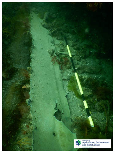
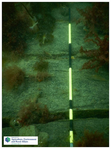
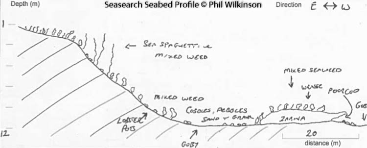
A sand and gravel slope leads out to the wreck from 1-12 metres. The wreckage is partially covered in sediment.

History: The history of the wreck provided by the Senior Marine Archaeologist from the Department for Communities Historic Environment Division (only included for wreck sites)

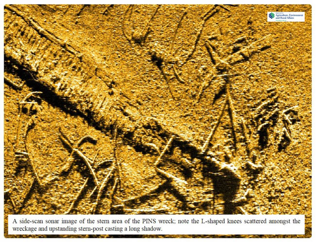
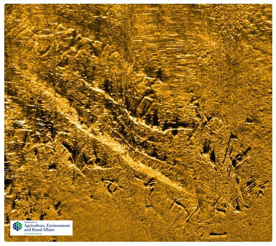
Date of loss uncertain (poss. Feb/March 1850). The ‘Pins’ wreck is generally thought to be that of the two-masted schooner, Nimble, built in Penzance in 1836 (although it is sometimes also attributed as the Zarina). The Nimble was en route from Glasgow to Dublin under Captain Savage with a general cargo. She took fire in Ballyhenry Bay and was a total loss. The ‘Pins’ nickname originated from the fact that many copper/brass pins/bolts were to be seen at the wreck. Sadly not the case presently as many have been taken over the years as souvenirs or for their salvage value. In June 1995, the Irish Underwater Archaeology Research Team (IUART) carried out a survey of the vessel producing a full plan of the vessel. This plan was later published (see Breen 1996). Marine scientists and archaeologists from the DAERA and DfC carried out a side-scan sonar survey in 2017 and a dive inspection in 2018. They noted a predominance of iron knees in and around the site and copper or muntz metal sheathing along the port side of the vessel. The remains of the wreck include the timber keelson, stern-post, framing and floor timbers and a scattering of iron fittings. A re-evaluation of the wreck is needed and an examination of the typology of these features might lead to a closer dating of the vessel and its identification.

(Sources: Breen 1996; CSP 1852-53 Vol. 98 p.398; WA B57). CSP (Commons Sessional Papers); WA (Wilson Archive)

Information derived from Historic Environment Record of Northern Ireland (HERoNI), Department for Communities, Historic Environment Division.

Biodiversity: A description of the species composition at the site. Species of interest are highlighted. Follow the links for more information about the species on the NBN Atlas Northern Ireland website

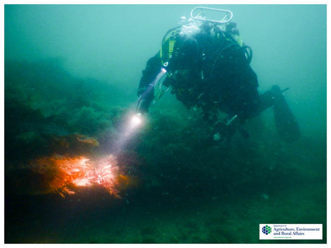
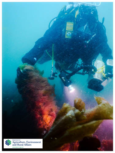
Patches of sugar kelp Saccharina latissima and mixed red algae are growing on the wreck. The orange sea sponge Suberites ficus has been recorded here and a variety of starfish species (including brittlestars which may be found on the sand that coats the wreck).

View all species records from this site

A link to the dive site location on the NBN Atlas Northern Ireland website, showing all species records from within a 1km boundary of the site centroid. Any new species records from the site submitted to Seasearch, iRecord, CEDaR Online Recording or iNaturalist will appear here
Local charters: A link to the website for the nearest Dive Centre to the site. A map of all dive centres is provided under ‘Go Diving’

D.V. Diving

Environmental and Historical Designations: A list of any environmental or historical designations attributed to the site, or overlapping it. Follow the link for more information

Strangford Lough MCZ
Strangford Lough SAC
Strangford Lough SPA
Strangford Lough RAMSAR

Safety: Safety tips

  • In an emergency call 999 or 112 and ask for the coastguard.
  • Follow VHF radio Channel 16 (156.8 MHz), the international distress frequency.
  • Find nearest defibrillator (AED) here
Latitude, Longitude: The approximate XY coordinates for the dive site in Decimel Degrees (DD). These can be converted to DMS or DDM by following the link below
54.388829, -5.564963

Watch more videos from SV Nimble’The Pins’

Leave a Comment

Dived here recently? Then let other divers know about this site from your experience!

Leave a Reply

Your email address will not be published. Required fields are marked *

This site uses Akismet to reduce spam. Learn how your comment data is processed.

Join our Mailing List